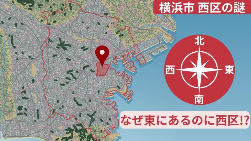
Why is it called Nishi Ward when it’s located on the east side of Yokohama?
“Where do you think Nishi Ward is located in Yokohama?”
If you ask someone this question and they answer “In the western part of Yokohama?”, that would be a perfectly natural response.
After all, it’s called “Nishi Ward” (West Ward).
But if you open a map, you’ll be surprised.
Nishi Ward is actually located in the “eastern part” of Yokohama.
Eastern location but called West Ward?
Completely the opposite of what you’d expect.
Is this a naming mistake!?
No, that can’t be.
There must be a proper reason for this.
So this time, we’ll unravel the mystery of
“Why is it called ‘Nishi Ward’ when it’s in the easternmost part of Yokohama?”
through maps, history, and analysis.
First, let’s review Nishi Ward’s location on the map!
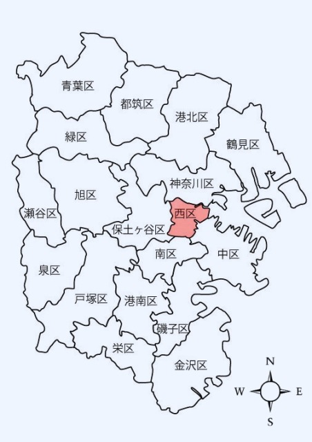
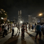
Yokohama City’s Nishi Ward is located in the eastern part of the city – centered around Yokohama Station, it encompasses part of the Minato Mirai 21 area.
It borders Kanagawa Ward to the north, Chuo and Minami Wards to the east and south, and Hodogaya Ward to the west, with ward boundaries following rivers and roads in a complex pattern.
The Katabira River flows through the ward and opens up near Yokohama Station, where various JR lines, the Sotetsu Main Line, and Yokohama Municipal Subway Blue Line intersect.
The area around the terminal station, where people flow and urban functions concentrate, could be considered the face of Nishi Ward.
Looking at the entire city, it’s not in the “west” but rather in the central to eastern part.
This geographical gap is exactly the starting point of our topic.
The Beginning of the Ward
To unravel the mystery of Nishi Ward, looking back at history is the shortcut.
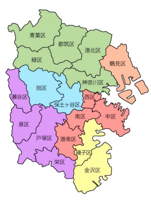
Current Yokohama City consists of 18 wards.
Originally, it was a collection of small counties and villages belonging to “Musashi Province” and “Sagami Province.”
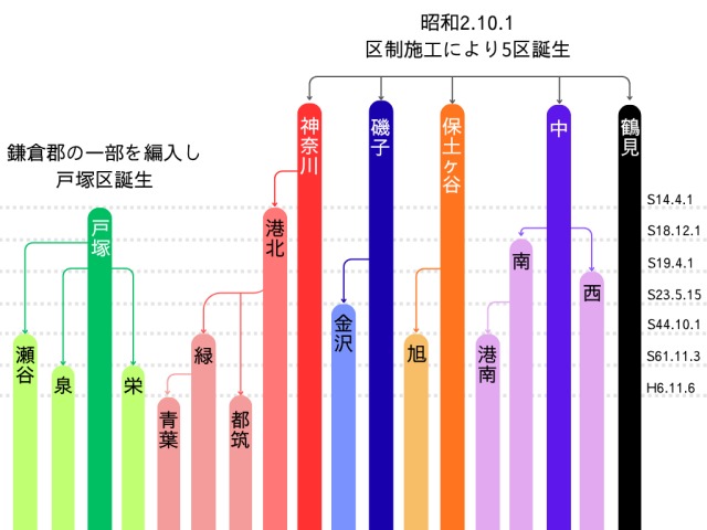
Yokohama City introduced the ward system in 1927 (Showa 2)
Starting with just 5 wards: Tsurumi Ward, Kanagawa Ward, Chuo Ward, Hodogaya Ward, and Isogo Ward!
Red = Former Chuo Ward
Green = Former Kanagawa Ward
Orange = Tsurumi Ward
Blue = Former Hodogaya Ward
Purple = Former Totsuka Ward
Yellow = Former Isogo Ward (incorporated into Yokohama City from Kamakura County)
From here, the city expanded, gradually adding new wards to become the current 18 wards.
Ward Transitions
Why did it become “Nishi”?
Far from being “west of Yokohama,” it’s actually more “eastern”
Given this location, why is it called “Nishi”? Actually, there are deep historical and administrative reasons hidden behind this.
◆ It was originally “part of Chuo Ward”!
Although Nishi Ward is now a bustling area encompassing Yokohama Station and Minato Mirai, it was originally part of Chuo Ward.
It was born in 1944 (Showa 19) when it separated and became independent from Chuo Ward.
The origin of the name is simply “because it was on the western side of Chuo Ward”
In other words, it wasn’t based on its position when looking at the entire city map, but rather the “west” when viewed within Chuo Ward.
◆ Actually related to “war”!?
But many might wonder why the division happened at this timing.
Actually, 1944 was right in
Nishi Ward
Nishi Ward is one of the 10 wards of Yokohama, Japan, and its name literally means “West Ward.” Historically, it developed significantly in the late 19th century with the opening of the Port of Yokohama, becoming a major industrial and residential area. Today, it is known for landmarks like the Mitsubishi Heavy Industries Yokohama Building and its large public parks, such as Mitsuzawa Park.
Yokohama Station
Yokohama Station is a major railway hub in Kanagawa Prefecture, Japan, serving as the primary gateway to the city of Yokohama. It first opened in 1872 as the terminal station for Japan’s first railway, connecting Yokohama to Shimbashi in Tokyo. Today, it has evolved into one of the busiest stations in the world, surrounded by extensive commercial and business districts.
Minato Mirai 21
Minato Mirai 21 is a large urban development and prominent business district in Yokohama, Japan. Its name, meaning “Harbor of the Future 21st Century,” reflects its origin as a waterfront redevelopment project initiated in the 1980s on former shipyard and industrial land. Today, it is famous for its modern skyline, landmarks like the Landmark Tower and Cosmo Clock 21 Ferris wheel, and its role as a major commercial and tourist center.
Kanagawa Ward
Kanagawa Ward is a coastal district in Yokohama, Japan, which historically developed as a major port and transportation hub following the opening of Yokohama to foreign trade in 1859. Today, it is a vibrant urban area known for its industrial zones, waterfront developments, and the iconic Osanbashi Pier. The ward also contains historical sites like the Kanagawa Prefectural Museum of Cultural History, reflecting its significant role in the Meiji Restoration and Japan’s modernization.
Chuo Ward
Chuo Ward is one of Tokyo’s 23 special wards and serves as a major commercial and financial hub, home to the famous Ginza shopping district and the historic Tsukiji Fish Market. Historically, much of the ward is built on reclaimed land from Tokyo Bay, and it was a central part of the old Edo city, where merchants and artisans thrived. Today, it blends its mercantile past with modern skyscrapers, representing the economic heart of Japan.
Minami Ward
Minami Ward is a central district in Yokohama, Japan, historically significant as one of the first areas opened to foreign trade in 1859. It is renowned for its vibrant Chinatown, one of the largest in the world, and the picturesque Yamashita Park waterfront. The ward’s history as an international port is reflected in its unique blend of Japanese and Western architecture, including the historic Yokohama Red Brick Warehouse.
Hodogaya Ward
Hodogaya Ward is one of the 18 wards of Yokohama, Japan. Historically, it was a bustling post town on the important Tokaido road during the Edo period, providing rest and lodging for travelers. Today, it is a primarily residential and commercial district within the modern city.
Katabira River
The Katabira River is a historically significant waterway in Japan, primarily known for its location in Gifu Prefecture. It gained prominence during the Sengoku period (1467–1615) as a natural moat for Sunomata Castle, which was famously built overnight by the warlord Toyotomi Hideyoshi. Today, the river is a scenic spot, appreciated for its role in local history and its tranquil, natural setting.