In the wave of digital transformation, grassroots governance is rapidly advancing toward intelligence. Recently, China Mobile Chongqing Company (referred to as “Chongqing Mobile”) partnered with Weituo Town in Hechuan District to introduce AI-powered drone inspection technology. Focusing on three key scenarios—”exposed garbage management, forest fire patrols, and illegal land use rectification”—this initiative leverages technology to address traditional governance challenges, injecting new energy into smart grassroots governance.
Technological Innovation: Overcoming Traditional Inspection Challenges
Traditional grassroots governance relies on manual inspections, which are inefficient and limited by terrain, weather, and other factors, leaving many blind spots. For example, in exposed garbage management, manual inspections struggle to cover hidden areas like backstreets and urban-rural junctions, making it difficult to promptly detect scattered waste and construction debris. In forest fire patrols, mountainous terrain complicates manual efforts, delaying fire detection. Similarly, illegal land use, such as unauthorized construction on farmland, often goes unnoticed due to its covert nature.
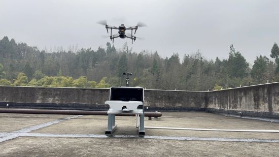
Now, drones equipped with high-definition cameras and AI recognition algorithms are transforming this landscape. Their agility and wide field of view allow them to quickly reach inaccessible areas. They can precisely identify waste, detect heat sources via thermal imaging, and monitor illegal farmland use (“non-agriculturalization” and “non-grain production”) through multispectral remote sensing and image comparison, exposing hidden issues.
Customized Routes: Precision in Grassroots Governance
To align technology with governance needs, Chongqing Mobile designed over 20 tailored inspection routes for Weituo Town.
For exposed garbage management, routes like “grid-based spiral scanning” and “highway vertical profiling” were created to cover commercial areas, urban-rural junctions, and roadsides, targeting high-risk zones like markets and pedestrian streets.
For forest fire patrols, “thermal imaging corridors” were mapped based on terrain, with increased patrols during fire-prone seasons, focusing on valleys and ridgelines.
For illegal land use, “farmland boundary monitoring routes” were established, using multi-temporal image comparisons to detect unauthorized activities like construction or mining on protected farmland.
To date, drones have completed over 1,000 patrols, identifying and facilitating the resolution of 320+ risk points.
Efficient Coordination: Building a Smart Governance Loop
With precise inspection data, governance processes operate more efficiently. The integration of AI drone technology with grassroots governance has created a closed-loop smart management system.
When anomalies are detected, drones use 5G to transmit real-time footage and data to Weituo Town’s command center. The “141” smart governance platform then assigns tasks to relevant departments via automated workflows, ensuring swift resolution and feedback.
This system has reduced garbage disposal time from 2 days to 4 hours, cut fire response time from 1 hour to 15 minutes, and improved illegal land use detection efficiency eightfold, shifting governance from “reactive” to “proactive.”
Currently, AI drone inspections support multiple critical tasks, including safety oversight, environmental cleanup, construction regulation, farmland protection, and fire prevention, transitioning governance from “fragmented” to “integrated.”
Moving forward, Chongqing Mobile will expand the technology’s applications, such as farmland monitoring and disaster response, to create efficient, eco-friendly towns and share replicable success models for other regions.