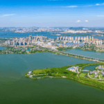
Along the riverbanks, the lush green shoreline now connects seamlessly. Walking along Wuhan’s 100-kilometer Yangtze River Ecological Corridor, residents marvel at how the once fragmented riverbanks have been fully connected, allowing unimpeded passage.
This transformation stems from a planning initiative five years ago. Today, that blueprint has become tangible benefits for people’s livelihoods.

The riverbanks along both sides of the Yangtze River within Wuhan’s Third Ring Road have been fully connected.
“Scientifically formulating and continuously implementing five-year plans is an important experience in our Party’s governance and a significant political advantage of socialism with Chinese characteristics,” emphasized the importance of five-year plans during a symposium on economic and social development for the 15th Five-Year Plan period.
Under the Party’s comprehensive leadership, medium and long-term planning ensures the continuity of national strategic will through scientifically set phased goals and roadmaps, guaranteeing that planning formulation and implementation align with national strategic intentions.
The beautiful and accessible river shoreline, the extensive subway network, and the pervasive “green genes” throughout the city… Working persistently to make plans effective and cities transform beautifully demonstrates the powerful advantages of China’s system.

How was this “blueprint” created?
Wuhan addressed the problems directly
By 2020, Wuhan’s riverbank development had progressed through multiple stages, becoming more extensive and refined, but issues also became apparent. Due to obstacles like docks and structures or missing natural shorelines, residents and tourists walking along the riverbanks encountered “breakpoints” where they had to turn back or detour, affecting their experience. Some riverbanks also lacked recreational facilities and green landscapes, making them less appealing.
A planning team conducted comprehensive surveys and research for the 100-kilometer Yangtze River Ecological Corridor project, proposing for the first time to integrate the river, shoreline, and city development simultaneously, formulating planning strategies from five dimensions: safety, ecology, culture, transportation, and vitality. The planning team fully respected the shoreline’s ecological environment and the development needs of adjacent areas, conducting comprehensive waterfront planning.
Targeting issues like discontinuous shorelines and insufficient core landmark landscapes and service facilities, the Wuhan 100-kilometer Yangtze River Ecological Corridor planned 16 projects. “We needed the spirit to tackle hard challenges, connecting each ‘breakpoint’ and ‘bottleneck’ one by one, no matter how difficult, we had to complete them.”
On the newly completed Jianghan Greenway, officials expressed mixed emotions. Over five years, they worked extensively with various stakeholders, communicating and coordinating to facilitate the relocation of numerous docks, enterprises, and organizations. As projects were completed one after another, the previously fragmented shoreline became connected like beads on a string.

Before this year’s National Day holiday, with the final two “breakpoints” connected, Wuhan’s riverbanks welcomed visitors with a completely new appearance—the 100-kilometer Yangtze River Ecological Corridor was completed as scheduled, fully connecting the riverbanks along both sides of the Yangtze River within Wuhan’s Third Ring Road. Wuhan residents now have continuous river viewing corridors totaling over 80 kilometers along both riverbanks. A resident from Minsheng Community expressed his delight: “Before, when going to the riverbank, we could only walk from Wuhan Ferry Terminal along Yanjiang Avenue past Wuhan Science and Technology Museum. Now, there’s a continuous path within the river embankment.”
Persisting with the blueprint
Relies on continuous effort
In a subway station, resident Liu Xiaowei pointed at Wuhan’s rail transit network map with excitement, “Over the past five years, the subway network has become increasingly dense, now connecting all urban districts.” The “network” she sees actually had a “blueprint” from the beginning.
By