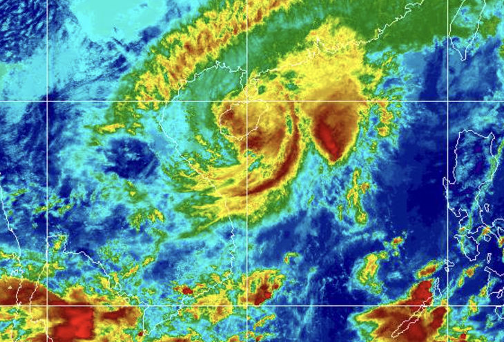
The National Center for Hydro-Meteorological Forecasting reported that this afternoon Typhoon Fengshen was located in the sea area northwest of the Paracel Islands, approximately 230km east-northeast of Da Nang City.
The maximum wind speed near the storm center reached level 10 (89-102 km/h), with gusts up to level 12. The storm is moving westward at 5-10 km/h.
Early tomorrow morning, the storm will move west-southwest at about 10 km/h, approximately 100km east-northeast of Da Nang, and gradually weaken.
Sea areas in the western part of the northern South China Sea (including the Paracel Islands) have strong winds at levels 7-8, with areas near the storm center experiencing levels 9-10 and gusts up to level 12. Sea waves are 3-5 meters high, reaching 5-7 meters near the storm center, with very rough seas.
Coastal areas from Quang Tri to Quang Ngai (including Con Co Island, Cu Lao Cham Island, and Ly Son Islands) have strong winds at levels 6-7, with areas near the storm path experiencing levels 8-9 and gusts up to level 11. Sea waves are 3-5 meters high with rough seas.
Storm surge along the coastal areas from Quang Tri to Da Nang City is expected to rise 0.4-0.8 meters.
Coastal and river mouth areas from Quang Tri to Da Nang City should prepare for large waves combined with high tides and storm surge, which may cause flooding in low-lying areas, wave overtopping of coastal and riverside roads, and coastal erosion.
All vessels, boats, and aquaculture areas in the mentioned danger zones are likely to be affected by thunderstorms, squalls, strong winds, large waves, and high tides.
On land, due to the influence of the storm circulation combined with strengthening cold air, provinces from Quang Tri to Da Nang will experience gradually strengthening winds up to level 6, sometimes level 7, with gusts of levels 8-9 tonight.
Due to the combined effects of storm circulation, cold air, easterly wind disturbances, and topographic effects, from tonight until October 24th, areas from Ha Tinh to Quang Ngai will experience heavy rain and thunderstorms.
Rainfall is generally expected to be 100-250mm, with some localized areas receiving very heavy rainfall exceeding 350mm. Particularly, areas from southern Quang Tri to Da Nang City will experience heavy to very heavy rain with general rainfall of 400-600mm, and some locations over 800mm (with intense rainfall concentrated from the night of October 22nd through the end of October 23rd).
Warning of risk of heavy rainfall exceeding 200mm/3 hours.
This week, strong cold air is causing cooler weather in the Northern region. The Central region is experiencing widespread rain due to the aftermath of typhoon number 12, while the Southern region has afternoon rain.
Paracel Islands
The Paracel Islands are a group of small islands and reefs in the South China Sea. Historically, both China and Vietnam have claimed sovereignty over the archipelago, but the islands have been under the control of the People’s Republic of China since a conflict with South Vietnam in 1974. The dispute over the islands remains a significant geopolitical issue in the region.
Da Nang City
Da Nang is a major coastal city in central Vietnam, historically known as a significant port during the French colonial era and the Vietnam War, where it hosted a major American air base. Today, it has developed into a vibrant economic hub and a popular tourist destination, famous for its beautiful beaches like My Khe, the modern Dragon Bridge, and its proximity to UNESCO World Heritage Sites such as Hoi An Ancient Town and the My Son Sanctuary.
Quang Tri
Quang Tri is a province in central Vietnam, most historically significant for its role during the Vietnam War. It was the location of the former Demilitarized Zone (DMZ) and the site of the intense 81-day Battle of Quang Tri Citadel in 1972. Today, it is home to poignant war memorials and remnants like the ancient citadel and the Hien Luong Bridge.
Quang Ngai
Quang Ngai is a coastal province in central Vietnam, historically part of the ancient Sa Huynh culture. It is most widely known for the tragic My Lai Massacre that occurred there during the Vietnam War, a site which now serves as a memorial. The province also features the stunning Ly Son Island, known for its volcanic landscapes and garlic farms.
Con Co Island
Con Co Island is a small island located off the coast of central Vietnam in the East Sea, known for its strategic military importance. During the Vietnam War, it served as a crucial logistical hub and base for the North Vietnamese army and the Viet Cong. Today, it is recognized as a historical site commemorating the resilience and sacrifices of Vietnamese soldiers.
Cu Lao Cham Island
Cu Lao Cham is a picturesque island cluster located off the coast of Hoi An in central Vietnam, recognized as a UNESCO World Biosphere Reserve. Historically, it served as an important trading port for the Champa Kingdom centuries ago, with evidence of this era found in ancient Cham temples and wells. Today, it is celebrated for its pristine beaches, diverse marine life, and rich coral reefs, making it a popular destination for eco-tourism.
Ly Son Islands
The Ly Son Islands are a volcanic archipelago off the coast of central Vietnam, historically known as a strategic outpost for the former Nguyen Lords. The islands are culturally significant as the home of the Hoang Sa Soldiers, who were sent by Vietnamese monarchs to patrol and establish sovereignty over the Paracel Islands and the surrounding sea.
Ha Tinh
Ha Tinh is a coastal province in north-central Vietnam, historically known as a cradle of revolutionary and scholarly traditions. It is home to the revered Hong Linh Mountain and the sacred temple of Princess Lieu Hanh. The region has a rich history of resistance against foreign invaders and has produced many of Vietnam’s most celebrated literary and political figures.