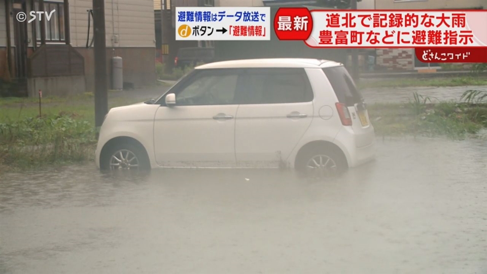
This is the scene in Toyotomi Town, Northern Hokkaido, around 3:00 PM on August 26th.
Sidewalks are flooded to the point where it is difficult for residents to walk.
The entire area has become like a river, with cars partially submerged up to their tires.
On the 26th, Hokkaido experienced record-breaking heavy rain, primarily in the northern regions, due to a low-pressure system accompanied by a front.
Toyotomi Town recorded 175.5 mm of rainfall in the 24 hours leading up to 5:30 PM, the highest in its observational history.
This exceeds the average total rainfall for the entire month of August.
Due to the risk of landslides, evacuation orders have been issued for some areas of Toyotomi Town, and three evacuation shelters have been set up within the town.
By 3:00 PM, more than 40 residents had evacuated.
(An evacuee) “Just like the rain on Sunday, it’s troubling. I wonder if I can even go home.”
Checking the radar, developed rain clouds approached Northern Hokkaido from around 6:00 AM and remained over the same area until 5:30 PM.
In Teshio Town, large puddles have formed on the road—
Cars are driving through, splashing water.
Evacuation orders have also been issued for some areas in Teshio Town.
“This is the scene in Wakkanai City at 8:00 AM. Heavy, large raindrops began to fall.”
In Wakkanai City, heavy rain also started from the morning of the 26th—
On the JR Soya Line, service between Otoineppu and Wakkanai has been suspended since around 1:00 PM for the entire day. Replacement buses are running once daily between Asahikawa and Wakkanai.
Northern Hokkaido was also hit by heavy rain last week.
Why is this pattern of heavy rain continuing?
“The pressure pattern has specific characteristics. Typically, a high-pressure system lingers to the south of Japan due to the remnants of summer. This year, its northward extension is stronger than usual. As a result, the jet stream flowing overhead is passing further north than normal. Low-pressure systems and fronts are riding along this, creating a situation where they pass easily over Northern Hokkaido. This pattern has persisted for the past week or two. The heavy rain, centered on the Soya region, is expected to peak through tonight. It is forecast to gradually weaken after midnight.”
The unstable atmospheric conditions due to the low-pressure system and front are not limited to Northern Hokkaido.
In Otobe Town, Southern Hokkaido, a large whirlwind-like phenomenon was also observed.
The peak of the rain in Northern Hokkaido is expected to last until the night of the 26th, with rain intensity forecast to weaken on the 27th. However, as the ground remains softened, continued caution and vigilance against landslides and other disasters are necessary.
Toyotomi Town
Toyotomi Town is a modern municipality in Hokkaido, Japan, established in 2006 through the merger of the former town of Toyotomi and the village of Hamatonbetsu. Its name, meaning “rich in people,” reflects its history as a region developed for agriculture and coal mining in the late 19th and early 20th centuries. The area is known today for its dairy farming and its proximity to the scenic Sarobetsu Wetland.
Teshio Town
Teshio is a small coastal town in northern Hokkaido, Japan, historically known for its herring fishing industry, which brought it prosperity in the late 19th and early 20th centuries. Today, its economy is based on fisheries and agriculture, and it is known for its scenic coastline and quiet, natural setting.
Wakkanai City
Wakkanai City is Japan’s northernmost city, located on the island of Hokkaido. Historically, it developed as a major port for fishing and trade, and it is known for its proximity to Russia’s Sakhalin Island. A key landmark is the Wakkanai Park, which features monuments symbolizing peace and a memorial tower overlooking the Soya Strait.
JR Soya Line
The JR Soya Line is a railway line in Hokkaido, Japan, operated by JR Hokkaido, which connects Asahikawa to Wakkanai, the northernmost station in the country. Historically, it was constructed in stages between 1903 and 1930 to support the development and transportation needs of the region’s agriculture and fishing industries. Today, it is a vital local transport route and a scenic journey offering views of rural Hokkaido and the Sea of Japan.
Otoineppu
Otoineppu is a village located in northern Hokkaido, Japan, known for being one of the coldest and snowiest inhabited places in the country. Historically, its development was tied to agriculture and forestry, with settlement expanding during Japan’s post-Meiji era push to develop Hokkaido. Today, it is a small, rural community that embraces its harsh climate and natural surroundings.
Asahikawa
Asahikawa is a city located in the mountainous center of Hokkaido, Japan, which developed in the late 19th century as a transportation and military hub. It is now famous for its vibrant food scene, particularly its unique style of ramen, and serves as the gateway to the Daisetsuzan National Park.
Soya region
The Soya region is the northernmost area of Japan, located on Hokkaido’s main island. It is historically significant as the homeland of the indigenous Ainu people and is known for the town of Wakkanai, which serves as a key port for trade and travel with Russia’s Sakhalin Island.
Otobe Town
Otobe is a small town located in the Hokkaido prefecture of Japan, historically developed around agriculture and forestry. It is notably home to the Otobe Onsen, a natural hot spring resort that has been a regional attraction for relaxation and recreation.