Typhoon Jangmi recently passed through Japan, prompting a “Level 5 Emergency Warning” for river flooding in Wakayama Prefecture, and “Level 4 Urgent Warnings” for heavy rain and other hazards in 11 prefectures stretching from the Kyushu region in southwestern Japan to the Kanto region in the eastern part of the country. Both are names under the new disaster prevention weather information system that began operation last week.
The system was revised to communicate danger clearly and prevent delays in evacuation. It must lead people to take action to protect their lives.
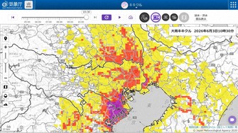
The new information organizes risks into five levels for each type of disaster: river flooding, heavy rain, landslide and storm surge. Level 1 is an early advisory, 2 is an advisory, 3 is a warning, 4 is an urgent warning and 5 is an emergency warning.
Until now, each type of disaster had been described with a variety of terms such as “danger information” and “alert information,” and it had been pointed out that those labels made it hard to tell how dangerous the situation really was. This stems from the fact that, as disasters become more severe and frequent due to factors such as climate change, the various types of information have been increased to encourage caution.
The new five-level information system is also linked to evacuation calls issued by local governments.
At Level 3, residents are advised to prepare for evacuation, while older people and others who need more time are urged to begin evacuating. At Level 4, everyone must evacuate from dangerous areas. By Level 5, a disaster may already be underway and people may no longer be able to go outside, which is why it is important to have completed evacuation by the Level 4 stage.
The authorities should analyze how residents in the affected areas acted during this typhoon and use the findings to improve the way information is communicated.
Measures were also introduced to make the level of danger easy to understand at a glance. Levels 1 through 5 are displayed using the colors white, yellow, red, purple and black, respectively. On the Japan Meteorological Agency’s website, people can also view real-time, color-coded risk maps.
Disaster-related information must also be communicated accurately to people with visual or hearing difficulties, older people who are not comfortable using the internet and foreigners who are not proficient in Japanese. The national and local governments need to take further steps to prevent disparities in access to information.
Communication about “linear precipitation bands,” which can cause major damage in a short period of time, has also been strengthened, with a new “immediate forecast” issued when the likelihood of their formation within two to three hours increases. However, this time, delays in announcements occurred because of a malfunction in the weather agency’s system.
Disaster-related information plays an important role in evacuation decisions. To enhance its reliability, the system must be operated with the utmost care.