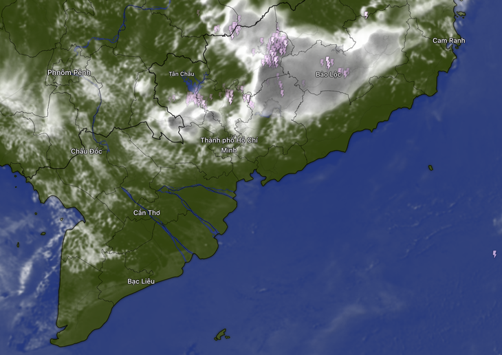
The Southern Hydrometeorological Station reports that monitoring satellite cloud images, weather radar, and lightning positioning shows storm clouds developing, causing rain accompanied by thunderstorms and lightning in the Tay Ninh province area.
In Ho Chi Minh City, storm clouds have appeared in the communes of Binh Khanh, Hung Long, Binh Chanh, Binh Hung, Nha Be, and the wards of Phu Dinh, Tan My, An Lac, Tan Hung, Binh Phu, Binh Tien, Chanh Hung, Tan Thuan, Binh Thoi, Dien Hong, Cho Quan, Cau Ong Lanh, Xom Chieu, An Khanh, Cat Lai, Ben Thanh, and Binh Trung.
In Dong Nai province, storm clouds are present in the communes of Dai Phuoc, Phuoc An, Nhon Trach, and Long Thanh.
From now until evening, storm clouds will continue to develop and cause showers with thunderstorms and lightning in the mentioned areas. Afterward, the clouds are expected to expand and spread to other nearby areas. Rainfall is generally between 2-20mm, with some places receiving over 20mm.
During the storms, be cautious of tornadoes, lightning, hail, and strong gusts of wind at levels 5-8 (8-21m/s), as well as heavy rain causing localized flooding.
Currently, Southern Vietnam is entering the transitional period between the dry and rainy seasons, with the southwest wind becoming active again.
However, rain will be scattered in only a few places, and hot sunny weather will still dominate daily weather patterns.
Forecasts for this year’s Hung Kings’ Festival holiday indicate that Northern and Central Vietnam will experience cool weather due to rain, while Southern Vietnam will have hot and sunny conditions.
Tay Ninh province
Tay Ninh province in southern Vietnam is best known as the birthplace and headquarters of the Cao Dai religion, a unique faith blending elements of Buddhism, Christianity, Taoism, and Confucianism. The province’s most iconic site is the Cao Dai Holy See, a vibrant and ornate temple built in the 1930s that serves as the religion’s administrative center. Historically, Tay Ninh also played a strategic role during the Vietnam War due to its proximity to the Cambodian border and the Ho Chi Minh Trail.
Ho Chi Minh City
Ho Chi Minh City, formerly known as Saigon, is the largest city in Vietnam and a major economic hub. It played a pivotal role during the Vietnam War, serving as the capital of South Vietnam until 1975, when it was renamed after the revolutionary leader Ho Chi Minh. Today, the city is known for its blend of historic French colonial architecture, modern skyscrapers, and vibrant street life.
Binh Chanh
Binh Chanh is a rural district located on the outskirts of Ho Chi Minh City, Vietnam. Historically, it was known for its agricultural land and traditional craft villages, though it has undergone significant urbanization and industrial development in recent decades. Today, Binh Chanh is recognized for its blend of modern infrastructure, such as the Binh Chanh Industrial Park, with remaining rural landscapes and cultural sites like the ancient Phu My Hung communal house.
<div class
Cao Dai Holy See
The Cao Dai Holy See, located in Tay Ninh, Vietnam, is the principal religious center of Caodaism, a syncretic faith founded in 1926 that blends elements of Buddhism, Taoism, Confucianism, and Christianity. Construction of the ornate temple began in 1933 and was completed in 1955, featuring a distinctive blend of Asian and European architectural styles, including a prominent eye symbol representing the faith’s divine eye. The site serves as the administrative and spiritual headquarters for the Cao Dai religion, hosting daily prayers and major ceremonies.
Binh Chanh Industrial Park
Binh Chanh Industrial Park is a key industrial zone located in Binh Chanh District, Ho Chi Minh City, Vietnam. Established in the early 2000s as part of the city’s economic expansion, it has developed into a hub for manufacturing and processing industries, including textiles, electronics, and food processing. The park plays a significant role in the region’s economy, attracting both domestic and foreign investment.
Phu My Hung communal house
Phu My Hung communal house is a traditional Vietnamese cultural site located in Ho Chi Minh City, originally built in the late 19th century by local villagers as a place of worship and community gathering. It honors the village’s tutelary deity and reflects the area’s rural heritage before urban development transformed the surrounding region. Today, it stands as a preserved historical landmark amidst the modern Phu My Hung urban area.
Ho Chi Minh City
Ho Chi Minh City, formerly known as Saigon, is Vietnam’s largest city and economic hub. It was the capital of French Indochina and later the capital of South Vietnam until the end of the Vietnam War in 1975, after which it was renamed. Today, it is a vibrant metropolis blending historic French colonial architecture, war remnants, and modern skyscrapers.
Tay Ninh province
Tay Ninh province, located in southern Vietnam near the Cambodian border, is best known as the birthplace and headquarters of the Cao Dai religion, a unique faith that blends elements of Buddhism, Christianity, Taoism, and Confucianism. The province features the striking Cao Dai Holy See temple in Tay Ninh City, built in the early 20th century, which serves as the religion’s administrative and spiritual center. Historically, Tay Ninh also played a strategic role during the Vietnam War due to its proximity to the Ho Chi Minh Trail and the Cu Chi Tunnels.
Saigon
Saigon, officially known as Ho Chi Minh City since 1976, is Vietnam’s largest city and economic hub. Originally a small fishing village, it became a major port and commercial center under French colonial rule in the 19th century, later serving as the capital of South Vietnam during the Vietnam War. Today, it blends modern skyscrapers with historic landmarks like the Notre-Dame Cathedral and the War Remnants Museum, reflecting its complex past.
Ho Chi Minh Trail
The Ho Chi Minh Trail was a vast network of supply routes running from North Vietnam through Laos and Cambodia into South Vietnam during the Vietnam War. Originally a primitive footpath, it was expanded into a complex system of roads, trails, and bridges to transport troops, weapons, and supplies, playing a crucial role in the North’s victory. Despite heavy U.S. bombing, the trail remained operational through constant repair and camouflage, and today it is a historic symbol of Vietnamese resilience.