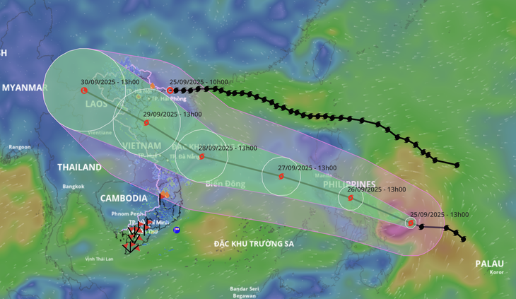
Typhoon Bualoi is very strong and could head straight into Da Nang – Hue or into the North Central region.
According to the National Center for Hydro-Meteorological Forecasting at 2:00 PM on September 25, the eye of Typhoon Bualoi was located over the sea area to the east. The maximum wind speed near the storm’s center reached level 12 (118-133 km/h), with gusts up to level 15.
Tomorrow night, Typhoon Bualoi enters the East Sea
It is forecast that around the night of September 26, Typhoon Bualoi will enter the eastern sea area of the central region, becoming the 10th storm of 2025.
Assessing the developments of Typhoon Bualoi on the afternoon of September 25, the National Center for Hydro-Meteorological Forecasting stated that after entering the East Sea, the storm is moving quickly in a northwesterly direction at a speed of about 25 km/h, heading towards the Paracel Islands (by September 28) with intensity continuing to increase, potentially reaching levels 12-13 – indicating a very strong typhoon.
“The forecast for its subsequent movement direction and final landing point currently lacks high reliability and is still scattered.
The storm’s path at this time depends on the activity of subtropical high-pressure systems in the coming days. Typhoon Bualoi could head straight into the Da Nang – Hue area or move along the coast towards the North Central and Northeast provinces.
Regardless of where the storm makes landfall, the risk of widespread heavy rainfall is very high due to the strong interaction between the storm’s circulation and the terrain.
Furthermore, shipping activities in the northern and central parts of the East Sea are at risk of being affected by very strong winds and high waves from approximately September 27 to 29,” the meteorological agency warned.
Why did Typhoon Ragasa weaken rapidly?
Also according to the National Center for Hydro-Meteorological Forecasting on the afternoon of September 25, the tropical depression (which weakened from Typhoon Ragasa – the 9th storm) had weakened into a low-pressure area over the Quang Ninh region.
It is forecast that this evening, the low-pressure area will continue moving mainly westward, continue to weaken, and dissipate.
Typhoon Ragasa formed off the coast of the Philippines on the morning of September 19 and rapidly intensified into a super typhoon after increasing by 8 levels in just over two days. On the night of September 22, Typhoon Ragasa entered the East Sea with an intensity of level 17 (202-220 km/h), with gusts exceeding level 17.
From the morning of September 24, as it moved to the sea area south of Guangdong province (China), due to friction with the terrain, combined with the dry air stream from cold air moving down from the north infiltrating the storm’s core, the typhoon’s intensity began to weaken.
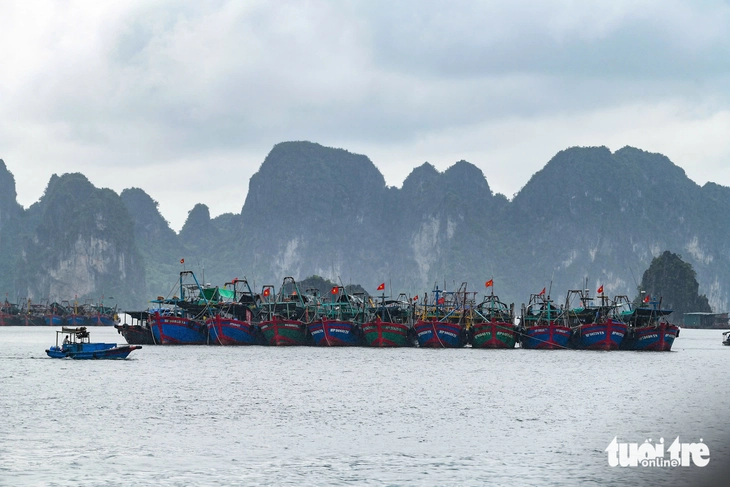
Ha Long Bay area at 10:00 AM on September 25
It was reported that by the afternoon of September 24, Typhoon Ragasa made landfall in the southeastern part of China’s Guangdong province, with part of its circulation over the sea and part over the Chinese mainland.
Due to friction with the terrain combined with the dry cold air mass from the north moving down, the typhoon’s intensity weakened rapidly.
By this morning, after passing the northern area of the Leizhou Peninsula, the storm continued to downgrade to level 8 and subsequently weakened further into a tropical depression over the sea area of Quang Ninh.
The meteorological agency stated that Ragasa is the strongest storm in the world so far in 2025, and is the strongest storm in the history of the East Sea.
Da Nang
Da Nang is a major coastal city in central Vietnam, historically known as a significant port during the French colonial era and the Vietnam War. Today, it is a vibrant economic hub famous for its stunning beaches, such as My Khe, and its proximity to UNESCO World Heritage Sites like the ancient town of Hoi An. The city is also home to modern landmarks like the Dragon Bridge and the Marble Mountains, a cluster of five limestone and marble hills with caves and Buddhist sanctuaries.
Hue
Hue served as the imperial capital of Vietnam during the Nguyen Dynasty from 1802 to 1945. Its most prominent feature is the Imperial City, a vast walled complex and UNESCO World Heritage Site located on the banks of the Perfume River. Though heavily damaged during the Vietnam War, the site’s grand palaces, temples, and royal tombs remain a major historical and cultural attraction.
Paracel Islands
The Paracel Islands are a disputed archipelago in the South China Sea, claimed in their entirety by China, Vietnam, and Taiwan. Historically, various Vietnamese dynasties and China have cited historical records to support their claims, but effective control has shifted over time. Since a 1974 military conflict, the People’s Republic of China has maintained continuous control over the islands, heavily developing military infrastructure there.
East Sea
The East Sea, also known as the Sea of Japan, is a marginal sea of the western Pacific Ocean. It is bordered by Japan, South Korea, North Korea, and Russia. The name “East Sea” has been used by Korea for centuries, reflecting its geographical position east of the Asian continent, while “Sea of Japan” became the more common international name in the early 20th century.
Quang Ninh
Quang Ninh is a coastal province in northeastern Vietnam, renowned for being home to the UNESCO World Heritage Site, Ha Long Bay. This iconic destination is famous for its thousands of limestone karsts and islands rising from emerald waters, with a geological history spanning over 500 million years. The area is also a significant cultural and economic hub, known for its rich history of coal mining and its importance in Vietnam’s developing tourism industry.
Ha Long Bay
Ha Long Bay is a UNESCO World Heritage Site in northeastern Vietnam, renowned for its stunning seascape of thousands of limestone karsts and islands. Its name, meaning “Descending Dragon Bay,” originates from a local legend that the islands were formed by a dragon plunging into the sea. The bay also holds significant geological value, with a history of over 500 million years of formation.
Leizhou Peninsula
The Leizhou Peninsula is a large peninsula in southern China’s Guangdong province, historically known as a strategic gateway to Hainan Island. It is renowned for its unique volcanic landscape, which has created fertile land for agriculture, particularly tropical fruits. The area also has a rich cultural heritage, being a center for the ancient Nanyue civilization and known for its distinctive Leizhou folk culture.
Guangdong
Guangdong is a coastal province in southern China with a long history as a major trading hub, historically known as Canton. It is the homeland of the Cantonese people and language and was a key starting point of the Maritime Silk Road. Today, it is one of China’s most populous and economically dynamic regions, home to the bustling Pearl River Delta megacity cluster, which includes Guangzhou and Shenzhen.