The Center for Analysis and Applying Geospatial Information (Cenago) at the Bandung Institute of Technology (ITB) has completed a forensic study based on extreme precipitation analysis, the hydrological characteristics of three watersheds (the Badiri, Garoga, and Batang Toru watersheds), land cover changes, and hydrological-hydraulic simulations.
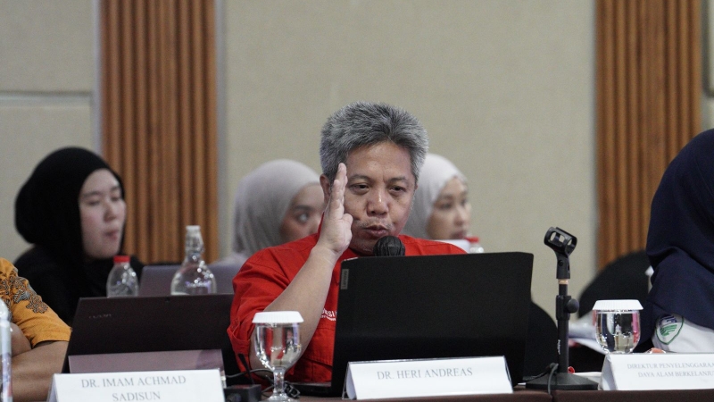
“The study results show that the event was triggered by rainfall of a very extreme intensity due to Tropical Cyclone Senyar, meaning the existing flood control system capacity was not designed to withstand an event of that scale,” said the Coordinator of the Cenago Research Team in a written statement.
Cenago states that this finding demonstrates the importance of data-driven depth and comprehensive analysis in drawing conclusions about the causal factors and accountability for a disaster.
“The research results show that the contribution of land cover changes by a number of analyzed corporations is relatively small compared to the scale of the extreme weather factor that occurred,” the statement explained.
Not only relying on the identification and digitization of satellite imagery to classify land cover, Cenago also combined precipitation data, watershed and sub-watershed definitions, digital elevation models (DEM), and standard hydrological-hydraulic parameter data.
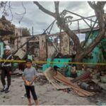
“Cenago’s analysis of high-resolution satellite imagery shows the flood was triggered by the Tropical Cyclone Senyar phenomenon with a very rare precipitation anomaly. Rainfall in late November 2025 reached extreme levels (150-300 millimeters per day) to very extreme levels (over 300 millimeters per day),” the statement clarified.
“With rainfall intensity exceeding the national mitigation standard, Cenago assesses that the disaster was at a level that, in terms of planning, exceeded the capacity of the applicable flood control measures,” it added.
Meanwhile, an ITB academic from the Geology Expertise Group added that landslide areas affected by massive extreme rainfall, occurring in the very steep Toba Tuff zone, are numerous in the upstream Garoga watershed and protected forests.
“There remains a very significant task, which is the use of data and information, such as geoscience data, for the examination and decision-making on various issues,” they stated.
Cenago is a research center at ITB focused on the analysis and application of geospatial information to support data-driven decision-making, including disaster forensic studies.
Cenago partners with operators of over 150 satellites related to High-Resolution Satellite Imagery (30 cm, super resolution 15 cm), Stereo Satellite Imaging, and SAR satellites utilizing radar signals, enabling the acceleration of geospatial information provision by more than 10 times.
Bandung Institute of Technology (ITB)
The Bandung Institute of Technology (ITB) is Indonesia’s oldest and most prestigious technical university, founded in 1920 during the Dutch colonial era as the *Technische Hoogeschool te Bandoeng*. It has played a pivotal role in the nation’s development, producing many of Indonesia’s leading engineers, scientists, and architects. The campus is also noted for its historic Art Deco buildings designed by Dutch architect Henri Maclaine Pont.
Center for Analysis and Applying Geospatial Information (Cenago)
The Center for Analysis and Applying Geospatial Information (Cenago) is a specialized institution in Vietnam, established to advance the research and practical application of geospatial technologies like GIS and remote sensing. It plays a key role in supporting national projects in areas such as environmental monitoring, urban planning, and natural resource management by providing critical data analysis and technical expertise.
Badiri watershed
The Badiri watershed is a significant ecological and cultural area located in the Badiri region of Papua New Guinea. Historically, it has been the ancestral land of the Maisin people, who have sustainably managed its rich rainforests and river systems for generations. Today, it is recognized for its biodiversity and the community’s efforts to protect their environment and cultural heritage.
Garoga watershed
The Garoga watershed is a protected natural area located in the Colombian Andes, primarily within the department of Antioquia. Historically, it has been vital for the region’s water supply and biodiversity, and its conservation efforts aim to protect its páramo ecosystems and the headwaters of several important rivers.
Batang Toru watershed
The Batang Toru watershed is a biodiverse rainforest region in North Sumatra, Indonesia, notable as the only known habitat of the critically endangered Tapanuli orangutan, discovered as a distinct species in 2017. Its history is deeply tied to local indigenous communities and, more recently, to conservation efforts and controversies surrounding infrastructure development, such as a major hydroelectric dam project within the ecosystem. This area represents a fragile balance between unique evolutionary history, endemic species conservation, and modern economic interests.
Toba Tuff zone
The Toba Tuff zone is a vast geological region in northern Sumatra, Indonesia, formed by the eruption of the Toba supervolcano approximately 74,000 years ago. This cataclysmic event, one of the largest known volcanic eruptions on Earth, deposited a layer of volcanic rock (ignimbrite) hundreds of meters thick across thousands of square kilometers. The area is now home to Lake Toba, the world’s largest volcanic lake, which fills the enormous caldera created by the volcano’s collapse.