Vietnam’s meteorological agency has raised the natural disaster risk warning due to Typhoon No. 5 (Kajiki) to level 4 (red alert, very high risk) for the mainland areas from Thanh Hoa to northern Quang Tri.
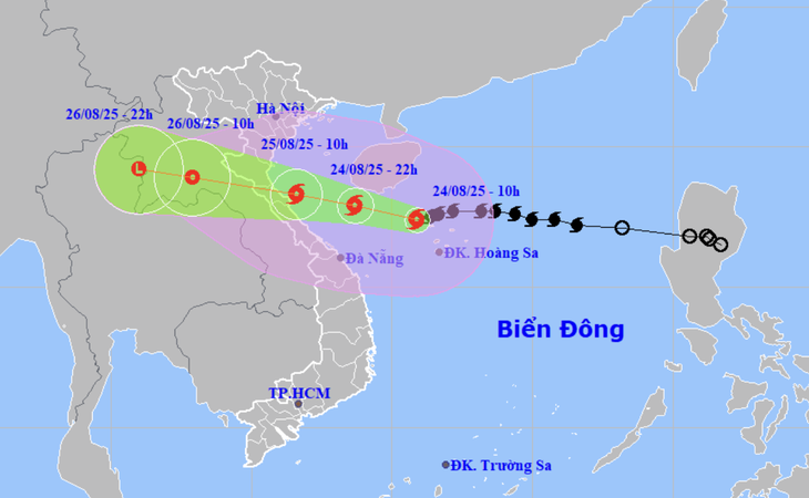
According to the National Center for Hydro-Meteorological Forecasting at 10:00 AM today, the storm is approximately 585 km from Nghe An and about 560 km east of Ha Tinh. Maximum wind strength is at level 12-13 (118-149 km/h), with gusts up to level 16.
Wind strength on land could reach levels 11-13, with gusts of levels 14-15
Notably, the meteorological agency forecasts that Typhoon No. 5 will continue to intensify throughout today and tonight. Its intensity could reach level 13-14 (134-166 km/h).
From tonight, mainland areas in the coastal provinces from Thanh Hoa to Quang Tri could begin to experience increasingly strong storm-force winds.
The typhoon is expected to make landfall around noon to afternoon tomorrow (August 25) and will cause a particularly dangerous combination of natural disasters.
“At sea, the typhoon causes strong to extremely strong winds up to levels 12-13, with gusts of levels 15-16, waves of 5-7 meters high, and areas near the storm’s center up to 8-9 meters. With such strong winds and large waves, it is extremely dangerous for ships, boats, and marine aquaculture cages; even large-tonnage vessels could be sunk.
For the mainland, there will also be impacts from strong winds up to levels 11-14, with gusts of levels 14-15. With winds this strong, infrastructure, houses, etc., that are not secure could suffer significant impacts and damage.
The typhoon’s circulation will also cause a widespread heavy rain event in the North Central and Northern regions, with localized rainfall reaching 600-700mm. Therefore, there is a very high risk of flooding, flash floods, and landslides.”
Typhoon No. 5’s wind strength is assessed to be not much weaker than Typhoon Yagi and at least equal to or greater than Typhoon No. 10 (Doksuri) in 2017.
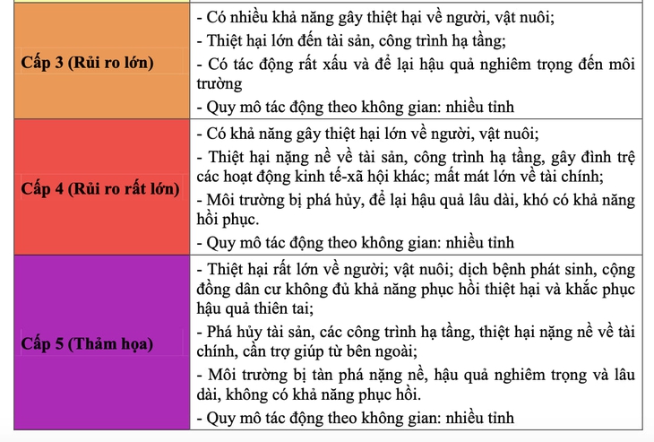
Therefore, the National Center for Hydro-Meteorological Forecasting has raised the natural disaster risk warning to level 4 – indicating a very high risk to people and property for the coastal areas from Thanh Hoa to Quang Tri and the mainland provinces from Thanh Hoa to northern Quang Tri.
In Vietnam, a typhoon with an intensity of level 10-11 is considered a strong typhoon, capable of knocking down trees, houses, power poles, and causing very severe damage and sinking sea vessels.
Furthermore, a typhoon with an intensity of level 12-15 is a very strong typhoon, with extremely destructive power. Sea waves are extremely powerful, capable of sinking large-tonnage sea vessels.
Localities (from Thanh Hoa to Quang Tri) are warned of a level 4 natural disaster risk – meaning Typhoon No. 5 could cause significant loss of life, livestock, severe damage to property and infrastructure over a wide area, halt socio-economic activities, and result in very large financial losses.
During Typhoon Yagi in 2024, the meteorological agency also issued a level 4 natural disaster risk warning for Quang Ninh and Hai Phong.
In reality, after Typhoon Yagi swept through, these two localities suffered heavy losses in terms of lives, houses, and infrastructure.
Ready to evacuate nearly 600,000 people to avoid Typhoon No. 5
According to a report from the Directorate of Dyke Management and Disaster Prevention to respond