Proposal to expand Nguyen Tat Thanh Road when implementing the Ben Thanh–Can Gio railway line.
After the route plan and construction positions along the route are approved, the related zoning plans and detailed plans along the route will be updated and adjusted accordingly.
To ensure a full legal basis, the Department of Planning and Architecture proposed that the city approve the route plan and construction positions along the route for the railway project after resolving some issues.
Specifically, approving the standards and technical standards applied to the project; approving the layout plan for the transition section between the underground and elevated sections in the area; and collecting additional opinions from units within the scope where the route plan and construction positions along the route have changed…
Perspective view of the Ben Thanh-Can Gio railway station.
The department also recommended assigning the Department of Construction to advise the city to submit to the Ho Chi Minh City People’s Council a decision on the investment policy for expanding Nguyen Tat Thanh road at the next session, through the investment policy and investment decision for the Nguyen Tat Thanh road expansion project, concurrently with the implementation of the Ben Thanh-Can Gio railway.
This project must be implemented simultaneously with the Ben Thanh-Can Gio line to ensure synchronization during the investment process.
According to the proposal, the project is executed by Vinspeed High-Speed Railway Investment and Development Joint Stock Company, with a total length of 53.8 km, double track, standard gauge of 1,435 mm, electrified, and a design speed of up to 350 km/h.
According to the design, the Ben Thanh-Can Gio railway line will run along the existing Rung Sac road.
Phase 1 plans to include 2 stations (Ben Thanh and Can Gio), and Phase 2 will add 4 more stations: Tan Thuan, Tan My, Nha Be, and Binh Khanh. Additionally, a depot and operations center will be located in Can Gio.
The Ben Thanh-Can Gio metro line starts at the 23/9 Park area (Ben Thanh station), passes through areas: Khanh Hoi, Xom Chieu, Tan Thuan, Tan My, Nha Be, Binh Khanh, An Thoi Dong, and ends at the Can Gio depot on a 39-hectare site.
The route alignment follows the streets Ky Con-Vinh Khanh-Hoang Dieu-Nguyen Tat Thanh-Nguyen Van Linh-Nguyen Luong Bang, then runs along the Rung Sac road corridor down to Can Gio.
Ben Thanh station
Ben Thanh Station is a major public transit hub located in the heart of Ho Chi Minh City, Vietnam, originally built during the French colonial period in the early 20th century. It serves as a central bus station connecting the city with nearby provinces, and in recent years, it has been integrated into the new Ho Chi Minh City Metro system. The station’s name and location are closely tied to the historic Ben Thanh Market, making it a key landmark in the city’s transportation and cultural history.
Can Gio station
Can Gio Station, located in the mangrove forest of Ho Chi Minh City, Vietnam, was a crucial base for the Viet Cong during the Vietnam War. It served as a key logistical hub for transporting troops and supplies along the waterways, leveraging the dense forest for cover. Today, the site is part of the Can Gio Biosphere Reserve, recognized for its historical significance and ecological importance.
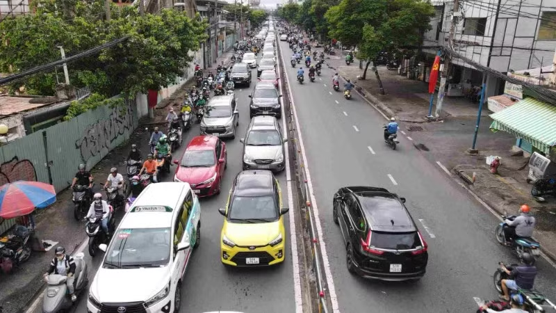
Nguyen Tat Thanh road
Nguyen Tat Thanh Road is a major coastal route in Nha Trang, Vietnam, named after the birth name of President Ho Chi Minh. It runs along the beautiful Tran Phu Beach and is lined with resorts, restaurants, and landmarks like the Po Nagar Cham Towers. The road honors Ho Chi Minh’s early life and revolutionary journey, reflecting the area’s blend of modern tourism and deep historical significance.
Rung Sac road
Rung Sac Road, also known as the “Blood Road,” is a historic military route in the Cần Giờ district of Ho Chi Minh City, Vietnam. It was constructed and used by the Viet Cong during the Vietnam War as a strategic supply line through the dense mangrove forests, serving as a vital link to the Saigon area. The road earned its grim nickname due to the fierce battles and heavy casualties that occurred there, and today it stands as a memorial to the war’s hardships and the resilience of those who fought.
Ky Con street
Ky Con Street is a historic lane located in the heart of Ho Chi Minh City, Vietnam, known for its classic French colonial architecture and vibrant street food scene. Originally established during the French colonial period, it has evolved from a quiet residential alley into a popular destination for both locals and tourists seeking authentic Vietnamese cuisine. Today, the street retains its old-world charm while bustling with modern life, offering a glimpse into the city’s rich cultural heritage.
Vinh Khanh street
Vinh Khanh Street is a famous food street located in District 4, Ho Chi Minh City, Vietnam, renowned for its vibrant nightlife and seafood offerings. Historically, it emerged as a bustling hub in the 20th century, particularly during the post-war economic reforms, when local vendors began setting up stalls that evolved into the lively market it is today. The street is now a popular destination for both locals and tourists seeking authentic Vietnamese street food, especially grilled seafood and snail dishes.
Hoang Dieu street
Hoang Dieu Street is a historic thoroughfare in Hanoi, Vietnam, known for its proximity to the Thang Long Imperial Citadel, a UNESCO World Heritage site. The street was named after Emperor Hoang Dieu, a 19th-century ruler who defended the citadel against French colonial forces. Today, it features a blend of French colonial architecture and government buildings, reflecting its deep historical and cultural significance in Vietnamese history.
Nguyen Van Linh street
Nguyen Van Linh Street is a major thoroughfare in Ho Chi Minh City, Vietnam, named after Nguyễn Văn Linh, a prominent communist revolutionary and former General Secretary of the Communist Party of Vietnam. The street historically links District 1 to District 7 and the Saigon Hi-Tech Park, playing a key role in the city’s urban development and economic expansion since the late 20th century. It is lined with modern commercial buildings, residential complexes, and cultural landmarks, reflecting the city’s rapid modernization.


![[Podcast] Trốn nghĩa vụ quân sự có thể bị phạt đến 75 triệu đồng](https://asiacity.news/wp-content/uploads/2025/08/tieu-chuan-suc-khoe-nghia-vu-quan-su-2024-17022820223812123762336-41-0-1265-1959-crop-1702282044778895511057-150x150.png)