Due to the impact of Storm No. 3, from tomorrow night (July 21), Hanoi will experience strong winds of level 6, with gusts up to level 7-8, along with heavy rain, posing significant dangers. Residents are advised to take precautions to protect lives and property.
Strong Storm Heads Toward Quang Ninh – Thanh Hoa, Affecting Hanoi
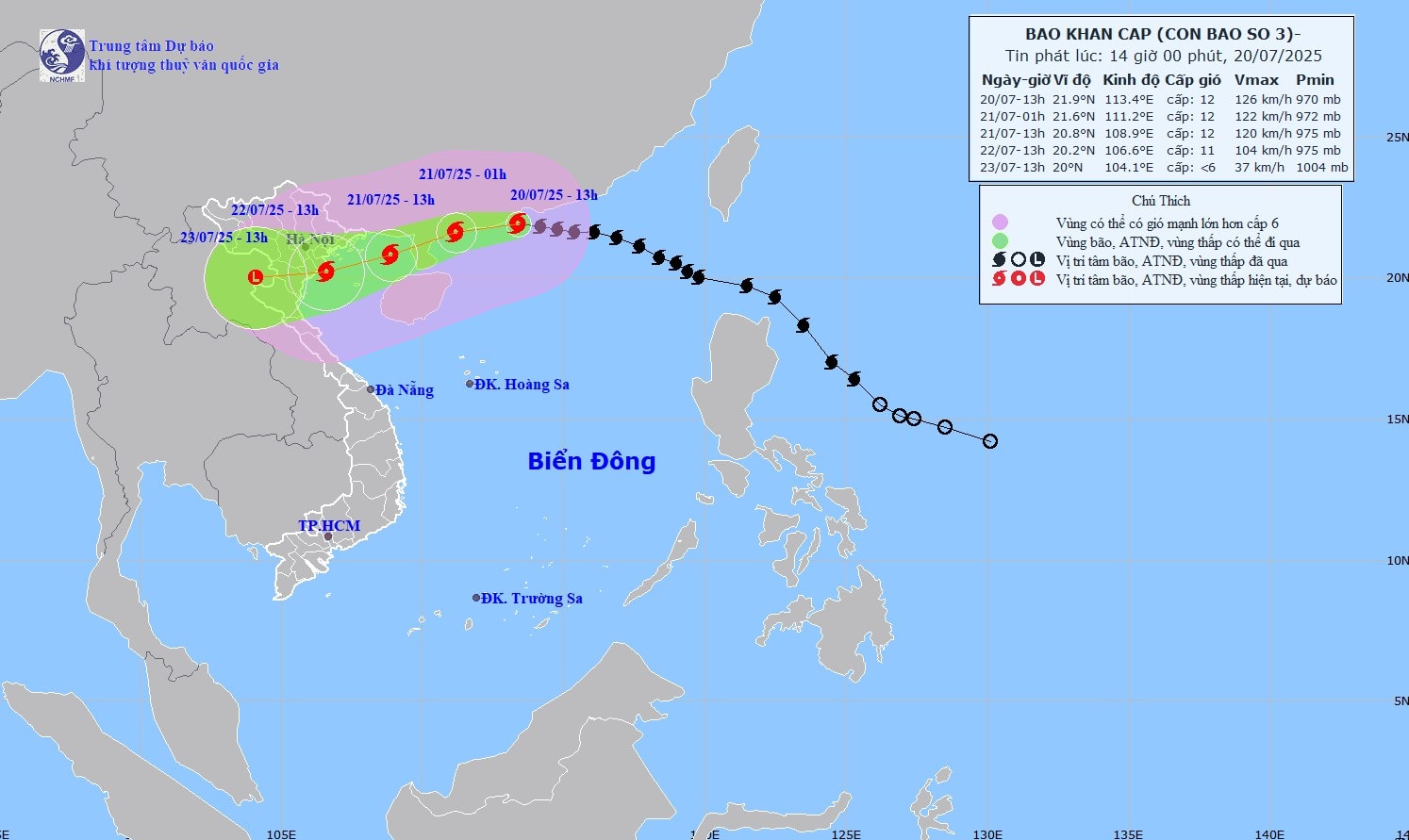
The National Center for Hydro-Meteorological Forecasting reported that at 1 PM on July 20, Storm No. 3 was approximately 630 km east of Quang Ninh – Hai Phong, with winds of level 12 (118-133 km/h) and gusts up to level 15.
Currently, the storm is moving westward at a speed of 20-25 km/h. By around 1 PM tomorrow (July 21), it is expected to enter the eastern waters of the northern Gulf of Tonkin with winds of level 11-12 and gusts up to level 15.
By 1 PM on July 22, the storm will make landfall in the coastal areas of Quang Ninh – Thanh Hoa provinces with winds of level 10-11 and gusts up to level 14. After this period, the storm will weaken into a tropical depression.
Due to the storm’s influence, from the night of July 20, the northern Gulf of Tonkin (including Bach Long Vi, Co To, Cat Hai, and Hon Dau islands) will experience gradually strengthening winds of level 6-7, later increasing to level 8-9. Areas near the storm’s center will face winds of level 10-11 with gusts up to level 14; sea waves will rise to 2-4 meters, reaching 3-5 meters near the storm’s center, with extremely rough seas.
The southern Gulf of Tonkin (including Hon Ngu Island) will also see winds strengthening to level 6-7, with areas near the storm’s center experiencing level 8-9 winds and gusts up to level 11. Sea waves will reach 2-4 meters, with very rough conditions.
On land, from the evening and night of July 21, coastal areas from Quang Ninh to Nghe An will experience winds gradually increasing to level 7-9, with areas near the storm’s center facing level 10-11 winds and gusts up to level 14. Inland areas will have winds of level 6-7, with gusts up to level 8-9.
From July 21 to 23, provinces and cities in the Northeast, the Red River Delta, Thanh Hoa, and Nghe An will experience heavy to very heavy rain and thunderstorms, with rainfall ranging from 200-350 mm, and some areas exceeding 600 mm.
Other areas in the North and Ha Tinh Province will see moderate to heavy rain, with some locations experiencing very heavy rain and thunderstorms, with rainfall ranging from 100-200 mm, and some areas exceeding 300 mm.
In Hanoi, from the night of July 21, northern and western districts will experience winds gradually increasing to level 4-5, with gusts up to level 6. Southern and central areas will see winds strengthening to level 4-5, later increasing to level 6 with gusts up to level 7-8. At this intensity, winds may uproot trees, damage roofs, livestock shelters, and temporary structures, posing risks to residents’ safety.
In addition to strong winds, from the afternoon of July 21 to the evening of July 22, Hanoi will experience moderate to heavy rain, with some areas seeing very heavy rain and thunderstorms. Rainfall is expected to range from 50-150 mm, with some areas exceeding 200 mm.
From the night of July 22 to July 24, Hanoi will continue to experience