Typhoon «Kammuri» makes landfall! Strong winds and torrential rain expected in some coastal areas! Please take precautions.
The National Meteorological Center continues to issue an orange typhoon warning:
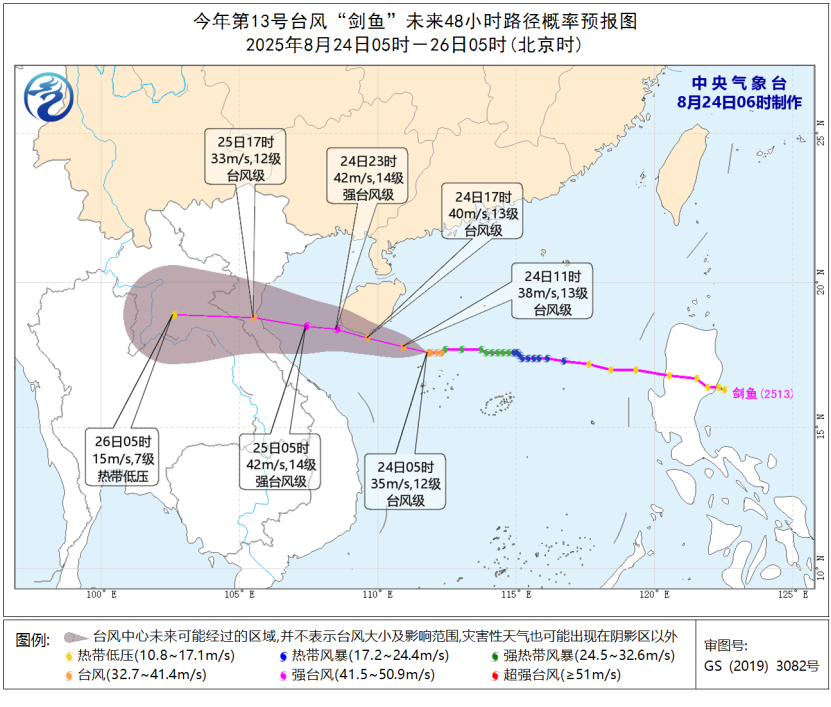
This year’s 13th typhoon, «Kammuri,» has intensified to typhoon strength early this morning. As of 5 a.m., its center was located in the western South China Sea, approximately 255 kilometers southeast of Sanya City, Hainan Province, at latitude 17.6 degrees north and longitude 111.8 degrees east. The maximum wind force near the center is scale 12 (35 meters per second), with a minimum central pressure of 970 hectopascals. The radius of the scale 7 wind circle is 200-220 kilometers, the scale 10 wind circle is 50-80 kilometers, and the scale 12 wind circle is 30 kilometers.
It is forecast that «Kammuri» will move west-northwest at a speed of about 20 kilometers per hour, continuing to intensify. It is expected to reach severe typhoon strength (scale 14-15, 42-48 meters per second) and make landfall along the coast from Lingshui to Ledong in Hainan between the afternoon and evening (scale 13-14, 40-45 meters per second, typhoon or severe typhoon strength). Alternatively, it may pass near the southern coast of Hainan Island before gradually moving toward the central-northern coast of Vietnam.
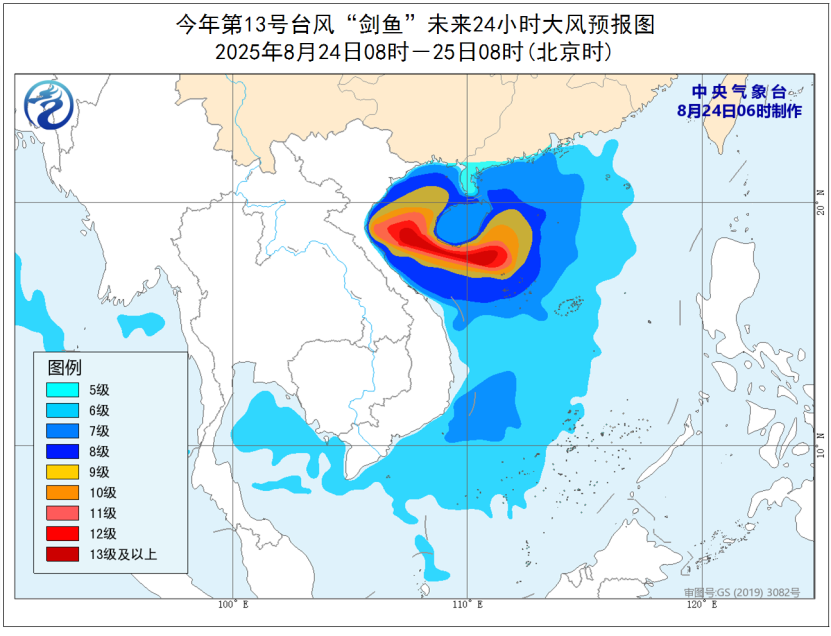
Wind forecast: From 08:00 on the 24th to 08:00 on the 25th, most of the South China Sea, the waters near the Xisha and Zhongsha Islands, the Beibu Gulf, the Qiongzhou Strait, Hainan Island and its coast, the coast of Guangxi, and the central-western coast of Guangdong will experience scale 6-8 winds. Areas including the northwestern and central-western South China Sea, parts of the Xisha Islands, the central and southern Beibu Gulf, and the coast of Hainan Island will have scale 9-11 winds. The wind force in areas near the path of «Kammuri» could reach scale 12-14, with gusts of scale 15-16.
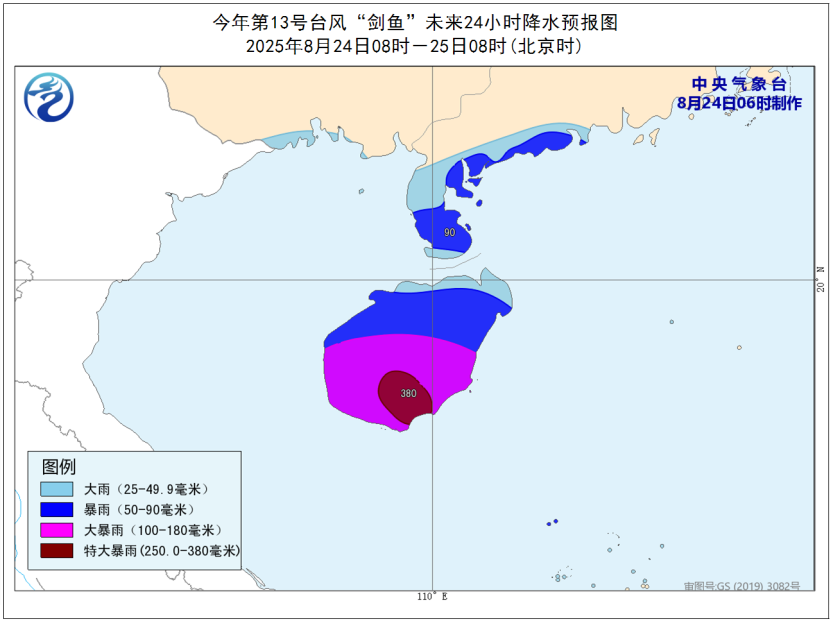
Precipitation forecast: From 08:00 on the 24th to 08:00 on the 25th, parts of Hainan Island, the southwestern coast of Guangdong, and the southern coast of Guangxi will experience heavy to torrential rain. The central and southern parts of Hainan Island will have torrential rain, with locally extreme torrential rain (250-380 millimeters).
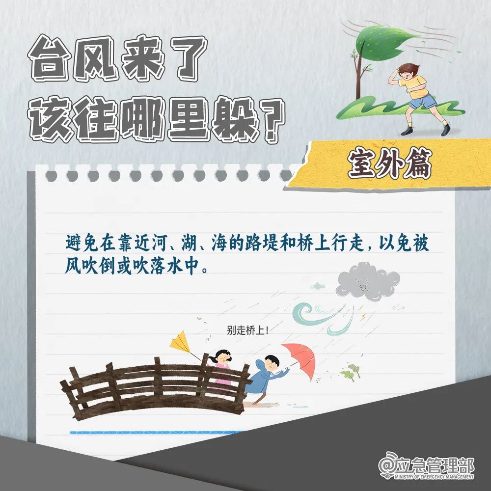
01 When a typhoon comes, where should you take shelter?
The South China Sea is a major marginal sea of the western Pacific Ocean, encompassing an area from Singapore to the Taiwan Strait. Historically, it has been a critical maritime trade route for centuries, connecting East Asia with the Indian Ocean and beyond. Its strategic and economic importance is underscored by ongoing territorial disputes among several nations over sovereignty of its islands and waters.
Sanya City
Sanya City is a popular tropical coastal destination on Hainan Island, China, historically serving as a key trading post. Today, it is renowned for its luxury resorts and beautiful beaches, such as those at Yalong Bay, and has been developed into an international tourism hub.
Hainan Province
Hainan Province is China’s southernmost and smallest province, consisting of various islands in the South China Sea, with Hainan Island being the largest. Historically, it was often used as a place of exile for officials during imperial times but has since developed into a major tourist destination and a key economic zone. It is renowned for its tropical climate, beaches, and distinct culture, which includes the indigenous Li people.
Xisha Islands
The Xisha Islands, also known as the Paracel Islands, are a group of islands in the South China Sea under the administration of China’s Hainan Province. Historically, Chinese sources claim the islands have been under Chinese control since ancient times, though this is a subject of regional dispute, particularly with Vietnam. Today, the islands are known for their strategic military importance and pristine coral reef ecosystems.
Zhongsha Islands
The Zhongsha Islands are a largely submerged atoll in the South China Sea, with Macclesfield Bank at its core. Historically, they have been a subject of territorial claims, primarily by China, Taiwan, and the Philippines. The area is also noted for its surrounding rich fishing grounds.
Beibu Gulf
The Beibu Gulf, historically known as the Gulf of Tonkin, is a semi-enclosed sea bordering southern China and northern Vietnam. It has been a significant maritime trade route for centuries, connecting East Asia with Southeast Asia. In modern times, it is a vital economic zone, central to the Beibu Gulf Economic Rim development strategy between China and Vietnam.
Qiongzhou Strait
The Qiongzhou Strait is a body of water separating China’s Leizhou Peninsula in Guangdong province from the northern coast of Hainan Island. Historically, it has served as a vital maritime corridor for trade and transportation, and its strategic military importance was notably demonstrated during the Hainan Island Campaign of 1950.
Hainan Island
Hainan Island is the southernmost province of China, historically used as a place of exile for officials during imperial dynasties like the Tang and Song. Today, it is a major tourist destination renowned for its tropical beaches, lush rainforests, and its status as China’s largest special economic zone.
Notice on the Issuance of the Action Plan for Prom...
Мы используем файлы cookie, чтобы обеспечить удобство работы с сайтом и анализировать трафик. Продолжая использовать сайт, вы соглашаетесь с нашей
[Политикой cookie]. 🍪