BAGUIO CITY – Officials of Baguio City and Benguet are calling for a comprehensive strategy to address the worsening condition of Kennon Road, as a newly built rockshed is already at risk of collapse due to soil erosion, less than a year after its completion.
A Benguet representative said Monday they have requested the Department of Public Works and Highways (DPWH) to immediately develop both short- and long-term solutions to keep the vital roadway open and safe.
He added that once a sustainable plan is finalized, he would lobby for national funding and congressional support.
Of Kennon Road’s 33-km. stretch, more than 25 km. lie within Benguet.
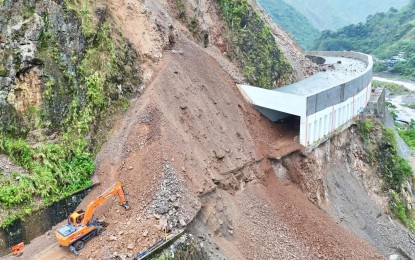
Despite suffering extensive damage from the 1990 Luzon earthquake, the road continues to undergo temporary “band-aid” fixes. The latest was a rockshed constructed to protect motorists from frequent landslides at Sitio Camp 6 in Barangay Camp 4.
A local mayor echoed the urgency in a media interview on Monday.
“There is a need for a serious dialogue with high-ranking officials of the DPWH to determine what needs to be done,” he said.
He also pushed the idea of auditing to assess not only natural factors like soil erosion, but also possible human errors, such as design deficiencies and construction lapses, that may have played a role in the incident.
He suggested that Kennon Road be privatized for better management.
“A thorough scrutiny will lead to a better master plan for Kennon,” he said.
“For us to maintain it, we should privatize it and prevent it from becoming a profit-driven structure.”
Kennon Road
Kennon Road is a historic mountain highway in the Philippines, connecting Baguio City to the lowlands of Pangasinan. Built by the Americans in 1903–1905 using mostly Filipino labor, it was named after Colonel Lyman Kennon, the engineer who oversaw its completion. Known for its steep zigzag routes and scenic views, it remains an important access route to Baguio, though landslides and newer highways have reduced its traffic over time.
Sitio Camp 6
Sitio Camp 6 is a small community in Tuba, Benguet, Philippines, known for its proximity to the Marcos Highway and its historical ties to the logging industry. The area was once a logging camp during the mid-20th century, with “Camp 6” referring to its position as the sixth station along the logging route. Today, it serves as a residential and agricultural area, with some locals still engaged in farming and small-scale trade.
Barangay Camp 4
Barangay Camp 4 is a barangay (village) located in Tuba, Benguet, Philippines, near the popular tourist destination Baguio City. Historically, it served as a settlement and transit point during the American colonial period, named after “Camp 4” of the Benguet Road construction camps used for building the Kennon Road in the early 1900s. Today, it is known for its scenic mountain views, strawberry farms, and as a gateway to hiking trails and outdoor adventures in the Cordillera region.
Baguio City
Baguio City, known as the “Summer Capital of the Philippines,” is a mountainous retreat established by American colonizers in the early 1900s. It became a popular hill station due to its cool climate and was designed by architect Daniel Burnham. Today, it is a vibrant cultural and tourist hub, famous for landmarks like Burnham Park, Session Road, and the annual Panagbenga Flower Festival.
Benguet
Benguet is a mountainous province in the northern Philippines, known for its cool climate, scenic landscapes, and rich indigenous culture. It is home to the Ibaloi and Kankanaey peoples, who have maintained traditional practices like the *cañao* rituals and terrace farming. The province is also famous for the Baguio City, a popular summer destination established during the American colonial era.
Department of Public Works and Highways (DPWH)
The **Department of Public Works and Highways (DPWH)** is the Philippine government agency responsible for the planning, construction, and maintenance of infrastructure, including roads, bridges, and public buildings. Established in 1868 during the Spanish colonial period as the *Obras Públicas*, it was later reorganized under American rule and officially became the DPWH in 1987. Today, it plays a key role in national development by improving transportation networks and flood control systems across the country.
1990 Luzon earthquake
The **1990 Luzon earthquake** was a devastating magnitude 7.7 quake that struck the island of Luzon, Philippines, on July 16, 1990, killing over 1,600 people and causing widespread destruction. Its epicenter was near Rizal, Nueva Ecija, and it severely damaged infrastructure, including buildings and bridges, notably in Baguio City and Dagupan. The disaster prompted improvements in the Philippines’ earthquake preparedness and building codes.
rockshed
A rockshed is a protective tunnel-like structure built over roads or railways in mountainous areas to shield them from falling rocks, landslides, or avalanches. These engineering solutions are common in regions with unstable terrain, such as Japan, the Alps, or the Himalayas, and help ensure safe transportation. Historically, rocksheds have evolved with advancements in construction techniques, often using reinforced concrete or steel to withstand natural hazards.