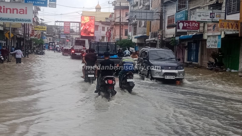
Heavy rain over two consecutive days caused the Padang, Bahilang, and Sibarau Rivers to overflow, resulting in major flooding in Tebing Tinggi City.
Data compiled from the local disaster management agency recorded that the overflow from these three rivers flooded residential areas in five districts and 18 sub-districts, affecting a total of 2,738 households, 1,999 homes, and 5,908 individuals. The following is a breakdown of the flooded areas:
In Tebing Tinggi District, the affected areas in Badak Bejuang Sub-district included 37 houses with water levels of 60–120 cm. The affected public facility was Pasar Inpres.
Next, in Bandar Utama Sub-district, 30 houses were affected with water levels of 40–80 cm. In Pasar Baru Sub-district, 53 houses were affected with water levels of 80 cm.
In Tebing Tinggi Lama Sub-district, 5 houses were flooded with water levels of 50–70 cm. In Pasar Gabir Sub-district, 15 houses were affected with water levels of 70 cm.
In Mandailing Sub-district, 1,000 houses were flooded with water levels of 40–90 cm.
In Rambutan District, the affected area in Sri Padang Sub-district included 50 houses with water levels of 50–60 cm.
In Bajenis District, the affected area in Bandar Sakti Sub-district included 69 houses with water levels of 30–70 cm. The affected facility was Pasar Sakti.
In Bulian Sub-district, 37 houses were flooded with water levels of 40–70 cm. Then, in Berohol Sub-district, 85 houses were affected with water levels of 40–50 cm, and in Durian Sub-district, 34 houses were affected with water levels of 70 cm.
In Padang Hilir District, the flooded area in Tambangan Hulu Sub-district included 17 houses with water levels of 10–30 cm. In Satria Sub-district, 45 houses were affected with water levels of 50–70 cm.
Finally, in Padang Hulu District, the flooded areas included Pabatu Sub-district with 45 houses and water levels of 10–30 cm, and Lubuk Baru Sub-district with 30 houses and water levels of 50 cm.
In Persiakan Sub-district, 220 houses were affected with water levels of 30–70 cm. In Padang Merbau Sub-district, 17 houses were affected. Meanwhile, data for Tualang Sub-district is awaiting an update.
It was explained that the flooding began to inundate residential areas starting at 06:00 and continued to spread throughout the day.
“This flood event was triggered by extreme rainfall in the upstream areas, namely Simalungun Regency and Serdang Bedagai Regency, which caused a drastic increase in river water discharge,” it was stated.
As of tonight, the flood conditions in Tebing Tinggi City are expected to continue rising, as the overflow from the Padang and Bahilang Rivers continues to enter residential areas.
Thamrin Road
Thamrin Road is a major thoroughfare in central Jakarta, Indonesia, named after the national independence hero Mohammad Husni Thamrin. Historically, it was developed in the mid-20th century and became a key part of the city’s modern urban planning. Today, it is a vital commercial and business artery, lined with skyscrapers, hotels, and the iconic Bundaran HI (Hotel Indonesia Roundabout).
Padang River
The Padang River is a significant waterway flowing through the city of Padang in West Sumatra, Indonesia. Historically, it has served as a vital transportation and trade route, connecting the inland Minangkabau highlands with the port on the Indian Ocean. Today, the river remains a central geographical feature of the city, though it is also known for its susceptibility to flooding during the rainy season.
Bahilang River
I am unable to provide a summary for the “Bahilang River” as I do not have any specific information about this location in my knowledge base. It is possible this is a local or lesser-known river. To find accurate details about its history and cultural significance, I would recommend consulting local geographical resources or cultural heritage websites.
Sibarau River
I am unable to provide a summary for the “Sibarau River” as I cannot find any significant cultural or historical information about a specific river by this name. It is possible this refers to a local or lesser-known geographical feature. For accurate details, it would be best to consult regional sources or local experts.
Pasar Inpres
Pasar Inpres is a traditional Indonesian market, typically built with funding from the Presidential Instruction (Inpres) program in the 1970s to foster local economic development. These markets serve as vital community hubs where vendors sell fresh produce, daily goods, and local crafts. While individual markets may vary, they collectively represent a government initiative to support small-scale traders and provide accessible shopping for residents.
Pasar Sakti
I am unable to provide a summary for “Pasar Sakti” as I do not have sufficient information about this specific place or cultural site in my knowledge base. It is possible it is a local market or site whose significance is not widely documented in general references. For accurate information, I would recommend consulting local historical records or tourism sources from the relevant region.
Simalungun Regency
Simalungun Regency is a region in North Sumatra, Indonesia, known for its scenic highlands and rich Batak culture. Historically, it was a significant kingdom, the Kerajaan Simalungun, which maintained its distinct identity among other Batak groups. Today, it is recognized for its traditional longhouses (rumah bolon) and its importance as a major producer of commodities like palm oil and tea.
Serdang Bedagai Regency
Serdang Bedagai Regency is an administrative region located on the east coast of North Sumatra, Indonesia. It was officially formed in 2003 from the merger of parts of the former Serdang and Bedagai territories, which were themselves remnants of historical Malay sultanates. The regency’s economy is primarily based on agriculture, particularly palm oil and rubber plantations.