Ensuring Flood Control Security, Water Supply Security, Food Security, and Ecological Security
On September 29, a press conference themed “High-Quality Completion of the ’14th Five-Year Plan'” was held. It was stated that since the start of the “14th Five-Year Plan,” new achievements have been made in water resources development, better ensuring flood control security, water supply security, food security, and ecological security.
Record High Investment in Water Conservancy Construction Last Year
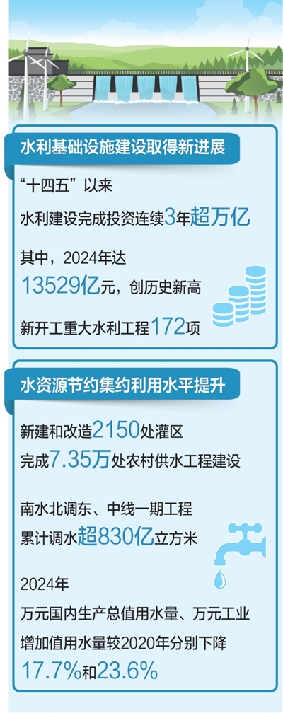
“Since the ’14th Five-Year Plan,’ investment in water conservancy construction has exceeded one trillion yuan for three consecutive years, reaching 1,352.9 billion yuan in 2024, a record high. During the ’14th Five-Year Plan’ period, total investment in water conservancy construction is expected to reach 5.4 trillion yuan, 1.6 times that of the ’13th Five-Year Plan’ period.”
Since the “14th Five-Year Plan,” 172 major water conservancy projects have commenced. By the end of 2024, the country had built 95,000 reservoirs, 200 large and medium-sized water diversion projects, 6,924 large and medium-sized irrigation areas, and 318,000 kilometers of embankments, forming the world’s largest, most comprehensive, and most populous water infrastructure system.
Since the “14th Five-Year Plan,” the proportion of flood disaster losses to GDP has decreased from 0.28% during the “13th Five-Year Plan” to 0.18%. Reservoir flood control capacity is 185.6 billion cubic meters, embankments protect 660 million people, national flood storage and detention areas have a capacity of 109 billion cubic meters, and there are 133,000 hydrological stations. Floods exceeding warning levels in 3,981 rivers have been overcome, including 223 rivers experiencing their largest recorded floods. Severe droughts in the Yangtze River, Pearl River, and other basins were effectively managed, ensuring drinking water security for affected populations and irrigation water needs for crops in drought-stricken areas.
“Digitalization, networking, and intelligentization are future trends and development directions.” Since the “14th Five-Year Plan,” systematic planning has advanced the construction of digital twin water systems, extending the flood forecasting period for major rivers nationwide from 3 days to 10 days.
What new progress has been made in national water network construction during the “14th Five-Year Plan” period? “The water resource allocation pattern of ‘south-north water transfer and east-west mutual support’ is accelerating, with national water network coverage expected to reach 80.3% by the end of this year.” Since the “14th Five-Year Plan,” construction has begun on 15 major water diversion projects, including the Middle Route of the South-to-North Water Diversion Project’s Yangtze River to Han River supplement, and 12 major water diversion projects, such as the first phase of the Yangtze River to Huaihe River Water Diversion, have been completed. 2,150 irrigation areas were newly built or renovated, and 73,500 rural water supply projects were completed. The South-to-North Water Diversion Project has fully utilized its role, with the East and Middle Route first phases transferring over 83 billion cubic meters of water, providing stable, high-quality water sources for 195 million people in 48 large and medium-sized cities along the routes, enhancing overall water resource allocation and supply security capabilities.
Achieving Zero Growth in Total Water Use Amid Economic Growth
“During the ’14th Five-Year Plan’ period, water resource conservation and intensive utilization capabilities and levels have further improved. Despite continuous significant economic growth and successive bumper grain harvests, total water use has achieved zero growth.”
How was this achieved? “Using water resources meticulously, strengthening the modernization and renovation of irrigation areas, implementing deep water conservation and control in the Yellow River Basin, and comprehensive water conservation in the water-receiving areas of the South-to-North Water Diversion Project’s East and Middle Routes have further improved water use efficiency and benefits. In 2024, water use per 10,000 yuan of GDP and per 10,000 yuan of industrial added value decreased by 17.7% and 23.6%, respectively, compared to 2020. Water-saving irrigation area reached 638 million mu, the effective utilization coefficient of farmland irrigation water rose to