
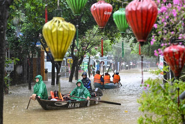
Vietnam is rethinking how it copes with floods after a year of relentless storms has collapsed hillsides and turned streets into rivers
Vietnam is rethinking how it copes with floods after a year of relentless storms collapsed hillsides and left vast parts of cities under water.
From mapping high-risk areas to reimagining “sponge cities” that can absorb and release water naturally, Vietnam is investing billions to adapt to what experts call a new era of climate extremes. Under a national master plan running through 2030, the government has pledged more than $6bn to build early-warning systems and move communities out of danger.
In smaller cities like Vinh in central Vietnam, these ideas are taking shape. Drainage networks are expanding, flood basins are being carved and riverbanks turned into green spaces that can absorb and then drain off after heavy rains.
An onslaught of storms this year has underscored the urgency of that work: Ragasa, Bualoi, Matmo – each carved its own path of ruin. Record rainfall turned streets into rivers and sent slopes sliding, with barely any time for the land to recover between storms.
Scientists warned it may not be the last. It’s a glimpse of the country’s climate future – warmer seas fuelling storms that form faster, linger longer, and dump heavier rain, hitting the poorest communities hardest.
Climate change is reshaping Vietnam’s storm season
Experts say the succession of storms battering Vietnam is not a fluke but part of a broader shift in how storms behave on a warming planet. Vietnam usually faces about a dozen storms a year, but the 2025 cluster was a “clear signal” of global warming.
Ocean waters are now nearly 1 degree Celsius (33.8 degrees Fahrenheit) warmer than before the industrial era. So storms carry more moisture.
The economic toll has been severe for Vietnam, a developing country that wants to become rich by 2045. Floods routinely disrupt farming, fisheries, and factories — the backbone of its economy. State media estimate extreme weather has cost the country $1.4bn in 2025.
Vietnam estimates it will need to spend $55bn–$92bn in this decade to manage and adapt to the impacts of climate change.
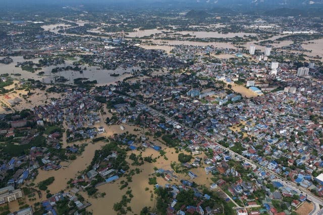
Vietnam’s cities aren’t built for climate shocks
About 18 million people, nearly a fifth of Vietnam’s population, live in its two biggest cities, Hanoi and Ho Chi Minh City. Both are on river deltas that once served as natural buffers against flooding. But as concrete spread over wetlands and farmlands, the cities lost their capacity to absorb downpours.
Flooding in Hanoi in October lingered for nearly a week in some neighbourhoods. The city of over 8 million has outgrown its infrastructure and its colonial-era drainage system failed as streets turned into brown canals. Motorbikes sputtered in waist-deep water and the Red River’s levees were tested.
Vegetable seller Dang Thuan’s home flooded knee-deep, spoiling her stock. Her neighbourhood used to have several ponds, but they were filled in to build houses and roads. Now the water has nowhere to go.
“We can’t afford to move,” she said, “So every time it rains hard, we just wait and hope.”
In 1986-1996, the decade coinciding with ‘Doi Moi’ economic reforms that unleashed a construction boom, Hanoi lost nearly two-thirds of water bodies in its four core urban districts, according to a study.
Between 2015 and 2020, it lost water bodies spanning the area of 285 soccer fields, state media have reported.
More than three-quarters of Hanoi’s area – including much of its densely populated