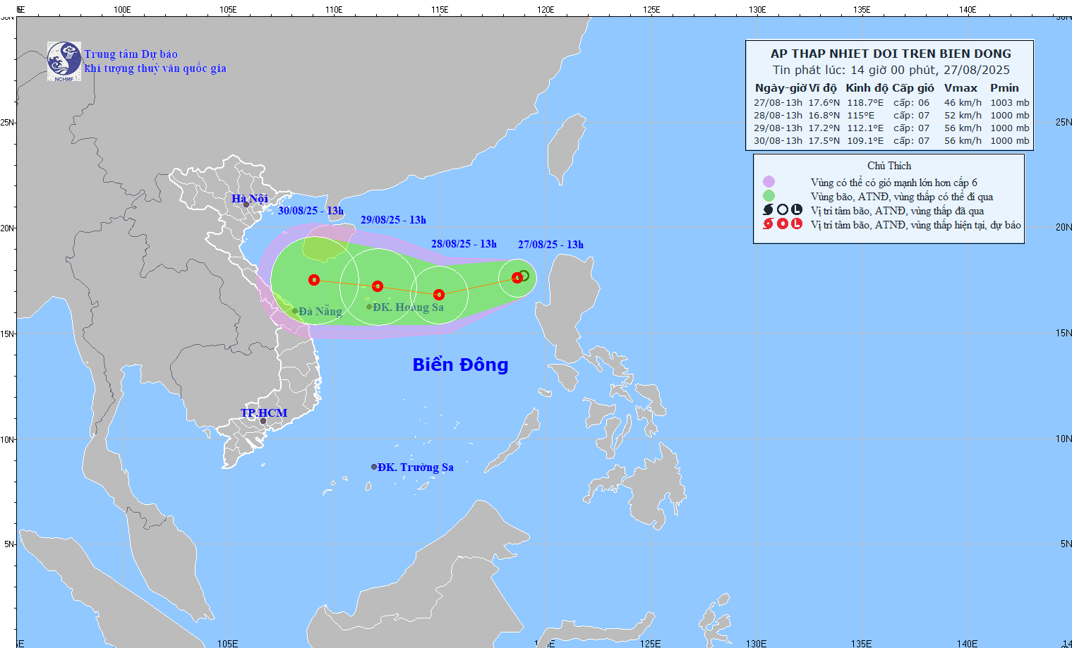
A low-pressure area offshore in the East Sea has intensified into a tropical depression. The Ministry of Agriculture and Environment has requested coastal provinces and cities from Quang Ninh to Khanh Hoa to focus intensely on disaster response.
The latest bulletin from the National Center for Hydrometeorological Forecasting states that the tropical depression is currently moving in a West-Southwest direction at a speed of 10-15 km/h; with maximum wind strength at level 6-7, and gusts up to level 9.
According to the hydrometeorological agency’s movement projection map, the tropical depression is heading straight for the Central region. Provinces and cities that were just severely affected by Storm No. 5, such as Nghe An and Ha Tinh, are among the localities that could be most significantly impacted.
To proactively respond to the tropical depression, on the afternoon of August 27, the Ministry of Agriculture and Environment issued a document requesting ministries, sectors, and the People’s Committees of coastal provinces and cities from Quang Ninh to Khanh Hoa to continue closely monitoring the developments of the tropical depression.
The key tasks are to strictly manage vessels going out to sea; to organize headcounts and notify owners of vessels and captains of ships operating at sea about the position, direction of movement, and developments of the tropical depression so they can proactively avoid, escape, or not move into dangerous areas.
The Ministry of Agriculture and Environment also requested localities to be ready with forces and means for rescue and relief operations when required. Ministries and sectors, according to their state management functions, tasks, and assigned duties, are to proactively direct and coordinate with localities in responding to the tropical depression.
A low-pressure area has formed over the sea area in the northern part of the East Sea. It is forecasted that in the coming few days, the low-pressure area will intensify into a tropical depression, affecting our country’s sea area.
A low-pressure area operating in the area east of the Philippines is moving quickly into the East Sea. It is expected that in the next 2-3 days, it could enter the Gulf of Tonkin, causing high waves and strong winds at sea, affecting the operations of ships and boats.
Due to the influence of the tropical depression, moderate to heavy and very heavy rain is forecasted for the area of Hanoi on August 18 and 19, 2025. The hydrometeorological agency warns of a series of extreme weather phenomena that could accompany the heavy rain.
East Sea
The East Sea, also known as the Sea of Japan, is a marginal sea of the western Pacific Ocean bordered by Japan, Korea, and Russia. Historically, it has been a vital region for trade, cultural exchange, and naval conflicts for the surrounding East Asian nations. The name itself is a subject of diplomatic contention, with South Korea advocating for «East Sea» and Japan using «Sea of Japan.»
Quang Ninh
Quang Ninh is a coastal province in northeastern Vietnam, renowned for being home to the UNESCO World Heritage Site of Ha Long Bay, famous for its thousands of limestone karsts and islands. Historically, the area has been a significant center for coal mining in Vietnam and was an important trading post within the ancient Van Don commercial port system.
Khanh Hoa
Khanh Hoa is a coastal province in south-central Vietnam, renowned for its popular beach resort city of Nha Trang. The area has a long history, once being part of the Champa Kingdom, and is home to the ancient Po Nagar Cham Towers, a Hindu temple complex dating back to the 7th-12th centuries. Today, it is a major tourist destination famous for its beautiful bays, islands, and vibrant marine life.
National Center for Hydrometeorological Forecasting
The National Center for Hydrometeorological Forecasting is Vietnam’s primary government agency responsible for weather forecasting, hydrology, and natural disaster warnings. It was established to monitor and predict meteorological phenomena, playing a critical role in national safety and economic planning. Its history is tied to the development of Vietnam’s modern meteorological service, providing vital data to protect the population and infrastructure from environmental hazards.
Nghe An
Nghe An is a coastal province in north-central Vietnam, historically significant as a fiercely independent region that often resisted foreign rule. It is most famously known as the birthplace of President Ho Chi Minh, the revolutionary leader of modern Vietnam. The province’s rich history is preserved in sites like his hometown in Kim Lien village.
Ha Tinh
Ha Tinh is a coastal province in north-central Vietnam, historically significant as a cradle of anti-colonial resistance and revolutionary movements against French rule. The region is also known for its rich cultural heritage, including the traditional Ví and Giặm folk songs, which are recognized by UNESCO.
Ministry of Agriculture and Environment
The Ministry of Agriculture and Environment is a governmental institution responsible for developing and implementing policies related to agriculture, forestry, fisheries, and environmental protection. Its history is tied to the modern development of the state, often evolving from separate ministries that were later merged to better address the interconnection between food production, natural resources, and sustainability. Its core mission is to ensure food security and the responsible stewardship of the nation’s natural environment.
Gulf of Tonkin
The Gulf of Tonkin is a body of water in the northwestern arm of the South China Sea, bordered by Vietnam and China. It is historically significant as the location of the 1964 Gulf of Tonkin Incident, which led to the direct involvement of the United States in the Vietnam War. The gulf has also been a vital maritime route for trade and fishing for centuries.


