The Japan Meteorological Agency made significant changes to its disaster prevention weather information at the end of May. The purpose of the improvements is to encourage residents to evacuate. Since this is crucial information for saving lives, the changes will be explained in several parts. The previous information was cluttered and difficult to understand. This time, the agency held repeated discussions with experts and organized the information to make it clearer. The new disaster prevention weather information is designed so that when a warning is issued, people can understand what evacuation actions they should take.
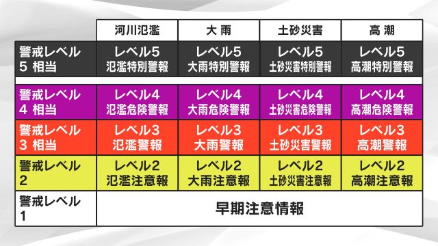
Figure 1 shows the new “disaster prevention weather information.” It is divided into five levels for “rivers,” “heavy rain,” “landslides,” and “storm surges” (warnings not listed in this table remain unchanged).
Each is linked to a “warning level that conveys evacuation actions,” and the name is preceded by “Level ○.”
Level 5 Special Warning: Emergency Safety Measures
Level 4 Danger Warning: Evacuation Order
Level 3 Warning: Evacuation for the Elderly, etc.
The level indicates the evacuation actions we must take.
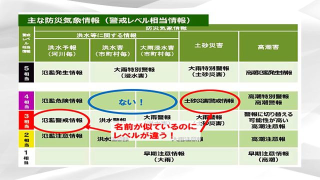
Figure 2 shows the previous disaster prevention weather information. There was a “Flood Warning Information” corresponding to Level 3 of flood forecasts, and a “Landslide Warning Information” corresponding to Level 4 of landslide disasters.
Despite both being called “warning information,” they were at different levels. Additionally, there was no Level 4 equivalent warning for flood damage or heavy rain inundation damage. The inconsistencies and gaps in these names have been resolved, making the system clearer.
Consequently, a new “Level 4 Danger Warning” has been introduced between “Level 3 Warning” and “Level 5 Special Warning.” The types of warnings have also been reviewed. This will be explained in subsequent parts.
As can be seen from Figure 1, the information is now clearer and easier to understand.
◇
Disaster prevention knowledge and wisdom learned from covering disaster areas and working as an NPO researcher will be shared in a column format.