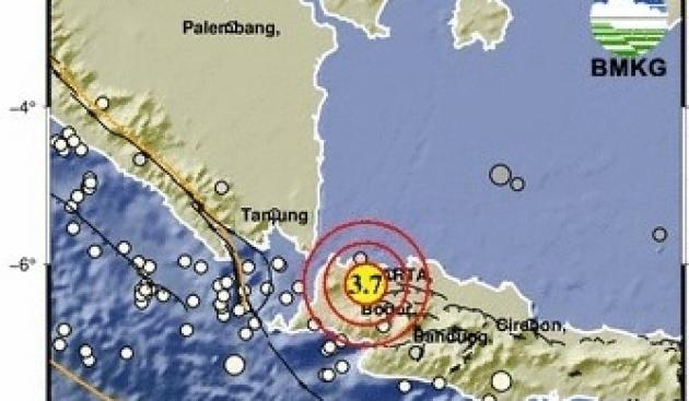
A 3.7 magnitude earthquake shook Tangerang Regency on Saturday night. (Special)
The Meteorology, Climatology, and Geophysics Agency reported a 3.7 magnitude earthquake that shook Tangerang Regency on Saturday.
The Head of the Regional BMKG Office confirmed the event. It was stated that the 3.7 magnitude earthquake occurred in the Tigaraksa area, Tangerang Regency, at 7:23 PM local time.
The earthquake’s location was at coordinates 6.25 S and 106.46 E, approximately 3 kilometers west of Tangerang Regency, Banten, with a depth of 161 kilometers. This earthquake is classified as an intermediate-depth quake.
It was further explained that this earthquake originated from subduction activity, specifically the process of the Indo-Australian Plate subducting beneath the Eurasian (Sunda) Plate south of Java Island.
“Earthquakes at depths greater than 100 kilometers generally occur within the subducting slab (intraslab), so they are not directly related to the activity of shallow active faults in the Banten or Tangerang mainland areas,” it was stated.
It was noted that initial BMKG information prioritizes speed, so the earthquake parameters may still change as data analysis is completed and updated.
“Currently, we have not received any reports regarding impacts or damage caused by the earthquake, and the tremor was also not felt by the public,” the statement said.
It was conveyed that coordination is ongoing with relevant stakeholders and other technical agencies to determine the earthquake’s impact on the community.
“If there are developments or reports that the earthquake had an impact and/or was felt by the public, we will immediately provide an information update,” it was added.
It was explained that the earthquake in that area does not have the potential to trigger aftershocks.
“BMKG continues to monitor seismic activity, and to date, there has been no further earthquake activity in the area,” the explanation concluded.
However, the public was advised to remain calm and continue to monitor official information from BMKG.
Tangerang Regency
Tangerang Regency is a regency in Banten Province, Indonesia, located on the western outskirts of the Jakarta metropolitan area. Historically, it was a significant settlement for Chinese immigrants in the 17th century and later became a major industrial and manufacturing hub in the late 20th century. Today, it is known for its mix of urban development, traditional *Batik* crafts, and historical sites like the Boen Tek Bio Temple.
Tigaraksa
Tigaraksa is a district in Tangerang Regency, Banten Province, Indonesia, historically known as an important trading post during the Dutch colonial era. Its name, meaning “Tiger’s Throne” in Sanskrit, reflects its past significance, and it was once a center for the cultivation and trade of agricultural products like coffee. Today, it functions primarily as a residential and industrial suburb of Greater Jakarta.
Banten
Banten is a historic province on the western tip of Java, Indonesia, which was once the center of the powerful Banten Sultanate, a major Islamic kingdom and a thriving international spice trade port from the 16th to early 19th centuries. Its most famous cultural site is the Grand Mosque of Banten, built in the 16th century, which showcases a unique architectural blend of Javanese, Chinese, and European influences. Today, the ruins of the sultan’s palace, fortifications, and the mosque stand as important reminders of the region’s past political and commercial significance.
Java Island
Java is Indonesia’s most populous island and the historical heart of its civilization, home to powerful Hindu-Buddhist kingdoms like Majapahit and the Islamic Sultanate of Mataram from the 8th to 16th centuries. It is globally renowned for its profound cultural heritage, including the UNESCO World Heritage sites of Borobudur (the world’s largest Buddhist temple) and Prambanan (a grand Hindu temple complex). Today, it remains the nation’s political and economic center, with the capital city of Jakarta located on its northwestern coast.
Indo-Australian Plate
The Indo-Australian Plate is a major tectonic plate in the Earth’s crust that includes the landmasses of India, Australia, and the surrounding Indian Ocean floor. It formed roughly 43 million years ago when the ancient Indian and Australian plates fused together after moving northward from Antarctica. Its ongoing collision with the Eurasian Plate created the Himalayan mountain range and continues to cause significant seismic activity in the region.
Eurasian Plate
The Eurasian Plate is a massive tectonic plate that primarily contains the continents of Europe and Asia. It formed over hundreds of millions of years through the amalgamation of smaller ancient continents and cratons. Today, its ongoing collision with the Indian Plate continues to uplift the Himalayan mountain range.
Sunda Plate
The Sunda Plate is a major tectonic plate in Southeast Asia, encompassing the majority of Indonesia, Malaysia, and parts of surrounding regions. Its history is defined by its ongoing collision with the Indo-Australian Plate, a process that has created the volcanic Sunda Arc, including islands like Java and Sumatra, and is responsible for the region’s frequent seismic and volcanic activity.