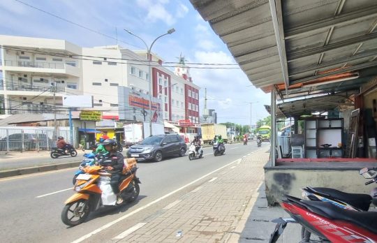
BEKASI CITY – The Bekasi City Government will reorganize the pedestrian areas along Jendral Sudirman Street, covering the area from the South Bekasi District to the West Bekasi District.
The Secretary of the Bekasi City Spatial Planning Agency stated that the demolition will be carried out on buildings standing on land owned by the Public Works Office. It is estimated
“Currently, we are still investigating the boundary between the land owned by the Public Works Office and the public. In the near future, a joint survey with the National Land Agency will be conducted to ensure no public rights are infringed,” the Secretary said during a confirmation.
It was explained that currently, the agency is still determining how many buildings will be affected by the demolition. Nevertheless, the enforcement of building regulations along Jenderal Sudirman Street will follow the contour of the land owned by the Public Works Office.
“That is what is still being investigated because the enforcement will follow the contour of the land owned by the Public Works Office,” it was elaborated.
The Secretary revealed that the Bekasi City Spatial Planning Agency had previously conducted public outreach regarding the pedestrian reorganization plan along Jenderal Sudirman Street.
“Outreach has been carried out by inviting the public to the Spatial Planning Agency. Regarding the schedule (for demolition), it is likely to be carried out within the next three weeks if the land status is clear,” it was emphasized.
Meanwhile, building owners stated they were aware that there would be enforcement actions on buildings affected by the pedestrian reorganization of Jenderal Sudirman Street.
“We already know there will be a demolition; a first warning letter from the Spatial Planning Agency has also been received by the building owner,” said one of the building owners.
Jendral Sudirman Street
Jendral Sudirman Street is a major thoroughfare in Jakarta, Indonesia, named in honor of General Sudirman, a revered national hero who commanded Indonesian forces during the country’s war for independence. Historically a key commercial and financial artery, it is now lined with skyscrapers, hotels, and shopping centers, symbolizing the modern economic heart of the capital.
Bekasi City
Bekasi is a city in West Java, Indonesia, historically known as a significant settlement during the Tarumanagara and Sunda kingdoms. It has transformed from a primarily agricultural area into a major industrial and residential satellite city for Jakarta. Today, it is one of Indonesia’s most populous cities and a crucial part of the Jakarta metropolitan region’s economy.
South Bekasi District
South Bekasi District is an administrative region within the city of Bekasi, West Java, Indonesia. Historically, the broader Bekasi area was part of the ancient Tarumanagara kingdom and later developed from agricultural lands into a major industrial and residential suburb of Jakarta. Today, it is a densely populated urban area known for its manufacturing hubs and residential complexes.
West Bekasi District
West Bekasi District is a rapidly developing urban administrative region within Bekasi City, located on the eastern outskirts of Jakarta, Indonesia. Historically, the area was part of the larger Bekasi Regency, known for its agricultural land, before being absorbed into the city’s expansion to accommodate the massive population and industrial growth driven by Jakarta’s sprawl since the late 20th century. Today, it is characterized by dense residential neighborhoods, shopping centers, and industrial estates, reflecting its transformation from a peri-urban area into a key metropolitan hub.
Bekasi City Spatial Planning Agency
The Bekasi City Spatial Planning Agency is a local government body responsible for managing urban development and land use regulations in Bekasi, Indonesia. It was established to implement Indonesia’s national spatial planning laws at the municipal level, guiding the city’s rapid growth and transformation from a primarily industrial area into a major residential and commercial hub in the Jakarta metropolitan region.
Public Works Office
The Public Works Office is a historic government building in Singapore, constructed in the late 19th century. It originally housed the colonial department responsible for the city’s infrastructure and was later renamed the Empress Place Building. Today, it is part of the Asian Civilisations Museum, showcasing its transition from an administrative centre to a cultural institution.
National Land Agency
The National Land Agency is a government institution in Indonesia responsible for managing land administration, including registration, surveying, and certification. It was established to implement the national agrarian reform agenda following the Basic Agrarian Law of 1960, aiming to ensure legal certainty and equitable land ownership. Its work is central to land rights, spatial planning, and resolving land conflicts across the country.