BUTUAN CITY – Government relief operations are in full swing across Mindanao as residents recover from successive strong earthquakes that struck the island in recent days, including the latest magnitude 6.0 tremor that hit Surigao del Sur late Saturday.
The earthquake, which was earlier recorded at magnitude 6.2, occurred 28 kilometers northeast of Cagwait, Surigao del Sur.
It was tectonic in origin and registered strong intensities in parts of Davao and Surigao provinces.
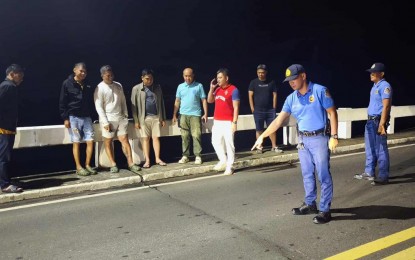
Authorities were still assessing structural damage in affected towns, including Tago, Surigao del Sur, where access to the Tago-Lapaz Bridge remained limited to light vehicles.
In an advisory issued Sunday, the bridge remained passable, but with one-at-a-time passage for all vehicles and no stopping zones while passing.
“Heavy six-wheeler trucks are allowed only if unloaded while 10-wheeler trucks are advised to take alternate routes or wait for clearance,” the advisory read.
As assessment and validation efforts continue, relief assistance will remain uninterrupted to help families recover.
More than 70,000 families or 253,938 individuals from 199 barangays across Agusan del Sur, Surigao del Norte, Surigao del Sur, and Dinagat Islands were affected by the series of tremors.
“All 2,933 families (11,317 individuals) who sought refuge in 58 evacuation centers have returned home, while nearly 7,000 families continue to stay with relatives and friends,” according to the latest update.
Eight houses were completely destroyed and 696 others sustained partial damage.
Humanitarian assistance sent to the affected residents has already reached PHP400,129.68, which included aids from other groups and organizations.
There are PHP168.7 million worth of relief resources on standby, including PHP2.7 million in standby funds and PHP166 million worth of food and non-food items.
Tago-Lapaz Bridge
The Tago-Lapaz Bridge is a vital infrastructure project in Surigao del Sur, Philippines, connecting the municipalities of Tago and San Agustin. Its construction was primarily aimed at improving transportation links and boosting the local economy in the Caraga region. While a relatively modern bridge, it plays a crucial role in replacing older, less reliable river crossings that were often disrupted by seasonal weather.
Tago
I am unable to provide a specific summary for “Tago” as it could refer to several different places. The most common is Tago, a municipality in the province of Surigao del Sur on the island of Mindanao in the Philippines, known for its coastal scenery and agricultural lands. Alternatively, it could be a reference to Mount Tago in the Philippines’ Bukidnon province. For a more accurate summary, please provide additional context, such as the country or region.
Surigao del Sur
Surigao del Sur is a province in the southern Philippines, on the eastern coast of Mindanao, known for its stunning natural landscapes. Its history is deeply tied to indigenous groups like the Manobo, and it was officially created as a province in 1960. The area is famous for its long coastline, the Enchanted River, and numerous pristine caves and waterfalls.
Cagwait
Cagwait is a coastal municipality in the Philippines, located in the province of Surigao del Sur on the island of Mindanao. It is historically known for its long, white-sand beach, often called the “Little Boracay of Surigao del Sur,” which has made it a popular local tourist destination. The area’s economy and culture have long been tied to the sea, with fishing and agriculture as traditional livelihoods.
Davao
Davao is a major city on the island of Mindanao in the Philippines, known for its proximity to Mount Apo, the country’s highest peak. Historically, the area was home to indigenous groups like the Bagobo before becoming a significant settlement under Spanish and later American colonial rule. Today, it is a bustling economic hub famous for its agricultural exports, such as durian, and its strict, orderly urban governance.
Agusan del Sur
Agusan del Sur is a province in the Caraga region of Mindanao, Philippines, known for its vast marshlands and lush rainforests. Its history is deeply rooted in indigenous cultures, particularly the Manobo people, who have inhabited the area for centuries. A key historical discovery was the Agusan Gold Image, a 21-karat gold statue found in the 1910s, which points to a rich, ancient civilization in the region.
Surigao del Norte
Surigao del Norte is a province in the southern Philippines, located in the Caraga region on the northeastern tip of Mindanao. Historically, it was a significant trading post before Spanish colonization and was officially established as a province in 1960. The area is renowned for its stunning natural attractions, including the surfing haven of Siargao Island and the Sohoton Cove Natural Bridge.
Dinagat Islands
The Dinagat Islands are a province in the Caraga region of the Philippines, known for their rugged landscapes, pristine beaches, and rich mineral deposits. Historically, the area was part of the Surigao provinces before becoming an independent province in 2006, and it holds significance as the home of the religious group PBMA (Philippine Benevolent Missionaries Association), founded by Ruben Ecleo Sr.